IMAGES TAKEN NEAR TO
Oak Grove, MONMOUTH, NP25 5PY
Introduction
This page details the photographs taken nearby to Oak Grove, NP25 5PY by members of the Geograph project.
The Geograph project started in 2005 with the aim of publishing, organising and preserving representative images for every square kilometre of Great Britain, Ireland and the Isle of Man.

There are currently over 7.5m images from over14,400 individuals and you can help contribute to the project by visiting https://www.geograph.org.uk
Image Map
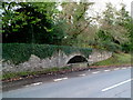
Images are licensed for reuse under creativecommons.org/licenses/by-sa/2.0
Notes
- Clicking on the map will re-center to the selected point.
- The higher the marker number, the further away the image location is from the centre of the postcode.
Image Listing (43 Images Found)
Images are licensed for reuse under creativecommons.org/licenses/by-sa/2.0
Image
Details
Distance
1
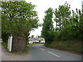
Oak Grove houses, Rockfield
There are two-storey houses on this (the west) side of Oak Grove.
The houses on the east side are all bungalows.
Image: © Jaggery
Taken: 22 Jan 2012
0.01 miles
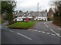
2
Former Rockfield post office
In common with many other locations in the UK, the village of Rockfield in Monmouthshire no longer has a post office. It used to be in this house at the eastern edge of Post Office Row.
The red band on the corner of the building is not a postbox. It's a red band.
Image: © Jaggery
Taken: 22 Jan 2012
0.03 miles
3
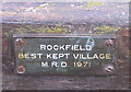
The glory days
38 years ago and still proudly displayed on a bench. Image
Image: © Pauline E
Taken: 7 Apr 2009
0.03 miles
4
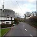
Entering Rockfield, or Llanoronwy
Heading northwest towards Newcastle on the B4347, or bearing left just around the corner on the B4233 to Abergavenny.
Image: © Pauline E
Taken: 7 Apr 2009
0.04 miles
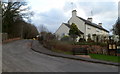
5
Rockfield village green
A fork in the old Monmouth to Abergavenny road forms the village green.
Image: © Jeremy Bolwell
Taken: 18 May 2012
0.04 miles
6
Village green and Post Office Row, Rockfield
The triangular village green contains Rockfield War Memorial. http://www.geograph.org.uk/photo/249008
The village post office used to be in the right corner building of Post Office Row.
Image: © Jaggery
Taken: 22 Jan 2012
0.04 miles
7
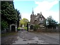
Gate house to The Hendre
The Hendre is a large Victorian house which originally belonged to the semi-aristocratic Rolls family.
Image: © Bikeboy
Taken: 8 Apr 2014
0.04 miles
8
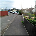
Towards Oak Grove houses, Rockfield
Viewed from the B4347 near the village noticeboard on the right.
The road leads to houses in the cul-de-sac Oak Grove. http://www.geograph.org.uk/photo/3551728
Image: © Jaggery
Taken: 22 Jan 2012
0.05 miles
9
Unsuitable for drinking, Rockfield
The trough is located near the village green. http://www.geograph.org.uk/photo/3551578
A Monmouth District Council notice on the wall states
THIS WATER SUPPLY IS UNSUITABLE FOR DRINKING IN ITS NATURAL STATE.
Image: © Jaggery
Taken: 22 Jan 2012
0.05 miles
10
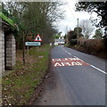
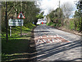
SE boundary of Rockfield, Monmouthshire
The road from Monmouth reaches the village of Rockfield. For several years the boundary sign also showed a would-be Welsh name for the village. http://www.geograph.org.uk/photo/1241400
After a long campaign by villagers, the signs were replaced in 2011 and now show only Rockfield. Llanoronwy had been added in 2004. The crux of the campaign for its removal was that detailed research had not found any evidence that Welsh (or English) speakers had ever used a name for the village other than Rockfield.
The Welsh Language Board's guidelines are that pedantic or antiquarian forms and literal or whimsical translations should be avoided unless they are in common use both locally and nationally.
Image: © Jaggery
Taken: 22 Jan 2012
0.05 miles