IMAGES TAKEN NEAR TO
Withy Lane, MONMOUTH, NP25 5LF
Introduction
This page details the photographs taken nearby to Withy Lane, NP25 5LF by members of the Geograph project.
The Geograph project started in 2005 with the aim of publishing, organising and preserving representative images for every square kilometre of Great Britain, Ireland and the Isle of Man.

There are currently over 7.5m images from over14,400 individuals and you can help contribute to the project by visiting https://www.geograph.org.uk
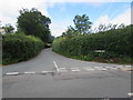
Image Map
Images are licensed for reuse under creativecommons.org/licenses/by-sa/2.0
Notes
- Clicking on the map will re-center to the selected point.
- The higher the marker number, the further away the image location is from the centre of the postcode.
Image Listing (36 Images Found)
Images are licensed for reuse under creativecommons.org/licenses/by-sa/2.0
Image
Details
Distance
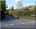
1
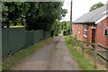
Withy Lane, Manson near Monmouth
Descending from the A466 Hereford Road past Buckholt Village Hall. http://www.geograph.org.uk/photo/2662459
Image: © Jaggery
Taken: 21 Aug 2016
0.07 miles
2
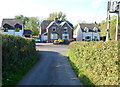
Hereford Road houses facing Manson Lane, Monmouth
Manson Lane is the northern continuation of Leasbrook Lane, a narrow country road from Dixton.
Image: © Jaggery
Taken: 22 Oct 2011
0.12 miles
3
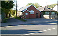
Buckholt Village Hall
Located south of the Buckholt boundary, in Manson's Cross, on the corner of the A466 and Withy Lane. The hall, built in 1929 by public subscription, is the centre of Buckholt activities. Among the many activities and clubs using the hall are the annual flower show, fete, Dramatic Society, Village Produce Association, youth club, the weekly Olde Tyme Dance Club, the Women's Institute, the Mothers' Union, mother & toddler group and table tennis club.
The hall committee arranges events such as musical evenings and coffee evenings to help maintain the hall for future generations.
Image: © Jaggery
Taken: 22 Oct 2011
0.12 miles
4
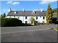
Grade II listed Old Inn Cottage, Monmouth
The Hereford Road building has two inscriptions on the wall at the level of the top of the upstairs windows.
The one on the left shows PE 1753; the one on the right shows EPE 1760. http://www.geograph.org.uk/photo/5084438
Old Inn Cottage was Grade II listed in October 2005.
Image: © Jaggery
Taken: 22 Oct 2011
0.13 miles
5
Eastern end of Manson Lane, Monmouth
Viewed across Hereford Road (A466). A white-on-blue sign shows that the lane is unsuitable for HGVs (heavy goods vehicles).
Image: © Jaggery
Taken: 22 Oct 2011
0.13 miles
6
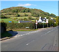
Corner of Manson Lane and Hereford Road, Monmouth
Viewed across Hereford Road (A466). Buckholt Wood is in the background.
Among the signs near the corner are a white-on-blue sign on the left showing that Manson Lane is unsuitable for HGVs (heavy goods vehicles). One of the Hereford Road signs warns of the possibility of deer in the road.
Image: © Jaggery
Taken: 22 Oct 2011
0.13 miles
7
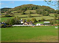
Monmouth : Hereford Road houses and a wooded hillside
Viewed from a Manson's Lane field gate adjacent to a depot. http://www.geograph.org.uk/photo/2662318
In the middle distance are buildings on Hereford Road, with the hilly backdrop of Buckholt Wood.
Image: © Jaggery
Taken: 22 Oct 2011
0.13 miles
8

Hedged-lined Manson Lane, Monmouth
From the corner of the A466 Hereford Road.
Image: © Jaggery
Taken: 21 Aug 2016
0.14 miles
9
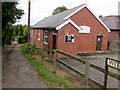
Buckholt Village Hall
On the corner of Withy Lane and Hereford Road, built in 1929 by public subscription.
http://www.geograph.org.uk/photo/2662459 to an earlier view and some details.
Image: © Jaggery
Taken: 21 Aug 2016
0.15 miles
10
Junction of Manson Lane and Hereford Road, Monmouth
The eastern end of Manson Lane viewed across the A466 Hereford Road.
Image: © Jaggery
Taken: 21 Aug 2016
0.15 miles