IMAGES TAKEN NEAR TO
Kemble Road, MONMOUTH, NP25 5GB
Introduction
This page details the photographs taken nearby to Kemble Road, NP25 5GB by members of the Geograph project.
The Geograph project started in 2005 with the aim of publishing, organising and preserving representative images for every square kilometre of Great Britain, Ireland and the Isle of Man.

There are currently over 7.5m images from over14,400 individuals and you can help contribute to the project by visiting https://www.geograph.org.uk
Image Map
Images are licensed for reuse under creativecommons.org/licenses/by-sa/2.0
Notes
- Clicking on the map will re-center to the selected point.
- The higher the marker number, the further away the image location is from the centre of the postcode.
Image Listing (4 Images Found)
Images are licensed for reuse under creativecommons.org/licenses/by-sa/2.0
Image
Details
Distance
1
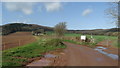
Track leading to Bailey Pit Farm from Watery Ln, Monmouth
Image: © Colin Park
Taken: 18 Apr 2018
0.17 miles
2
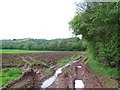
Offa's Dyke Path near Bailey Pits
The National Trail after just leaving the asphalt of Watery Lane to a particularly squelchy section
Image: © Chris Heaton
Taken: 8 May 2006
0.20 miles
3
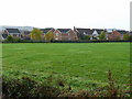
Recently-built housing
Part of the Brook estate on the western edge of Monmouth, viewed from the Rockfield Road.
Image: © Jonathan Billinger
Taken: 24 Oct 2008
0.20 miles
4
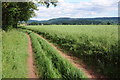
The route of Offa's Dyke Path
Offa's Dyke Path follows this track as it approaches Watery Lane and the county town of Monmouth. The crop in the field to the right is oilseed rape with the seed pods forming after the bright yellow flowers have gone.
Image: © Philip Halling
Taken: 9 Jun 2012
0.23 miles