1
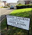
Bowen Gardens, Monmouth
Cul-de-sac on the northeast side of the road named Kings Fee. The houses were built in the second decade of the 21st century. The sign on the right shows BOWEN GARDENS LEADING TO TREVOR BOWEN HOUSE. The sign text is also in Welsh.
Image: © Jaggery
Taken: 12 Jul 2020
0.02 miles
2
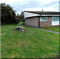
Tree stump, Kings Fee, Monmouth
Viewed in late October 2014. A Google Earth Street View taken in September 2009 shows a dominant tree here, some of its branches and leaves partially over the bungalow. I suppose it had to go...
Image: © Jaggery
Taken: 26 Oct 2014
0.02 miles
3
The Retreat, Kings Fee, Monmouth
Bungalows in the NE corner of Kings Fee.
Image: © Jaggery
Taken: 26 Oct 2014
0.02 miles
4
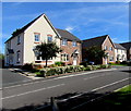
Modern houses, Bowen Gardens, Monmouth
Houses built in the second decade of the 21st century viewed from the corner of Kings Fee in July 2020.
Image: © Jaggery
Taken: 12 Jul 2020
0.03 miles
5
Bowen Gardens house construction in Monmouth
Viewed across Kings Fee in late October 2014. This is part of a Capsel and Lovell development of two and three bedroom houses. This used to be the site of sheltered housing in Trevor Bowen Court http://www.geograph.org.uk/photo/2068702
Image: © Jaggery
Taken: 26 Oct 2014
0.03 miles
6
House construction in Bowen Gardens, Monmouth
Viewed across Kings Fee in late October 2014. This is part of a Capsel and Lovell development of two and three bedroom houses, formerly the site of sheltered housing in Trevor Bowen Court. http://www.geograph.org.uk/photo/2068702
Image: © Jaggery
Taken: 26 Oct 2014
0.03 miles
7
Bilingual name sign on an Overmonnow corner, Monmouth
The sign on the right here https://www.geograph.org.uk/photo/6533932 shows that BOWEN GARDENS is GERDDI BOWEN in Welsh.
Image: © Jaggery
Taken: 12 Jul 2020
0.03 miles
8
Padlocked entrance to Kings Fee construction site, Monmouth
No work on the Capsel and Lovell development of two and three bedroom houses today,
a Sunday in late October 2014.
Image: © Jaggery
Taken: 26 Oct 2014
0.04 miles
9
Solar panels, Kings Fee, Monmouth
In late October 2014, most of the roofs have solar panels.
There were none here in a Google Earth Street View taken in September 2009.
Image: © Jaggery
Taken: 26 Oct 2014
0.04 miles
10
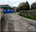
Williams Field Lane, Monmouth
Viewed from Wonastow Road in October 2014, when Bowen Gardens house
construction is in progress on the site of the demolished Trevor Bowen Court.
Image: © Jaggery
Taken: 26 Oct 2014
0.04 miles


