IMAGES TAKEN NEAR TO
Drybridge Gardens, MONMOUTH, NP25 5BR
Introduction
This page details the photographs taken nearby to Drybridge Gardens, NP25 5BR by members of the Geograph project.
The Geograph project started in 2005 with the aim of publishing, organising and preserving representative images for every square kilometre of Great Britain, Ireland and the Isle of Man.

There are currently over 7.5m images from over14,400 individuals and you can help contribute to the project by visiting https://www.geograph.org.uk
Image Map
Images are licensed for reuse under creativecommons.org/licenses/by-sa/2.0
Notes
- Clicking on the map will re-center to the selected point.
- The higher the marker number, the further away the image location is from the centre of the postcode.
Image Listing (540 Images Found)
Images are licensed for reuse under creativecommons.org/licenses/by-sa/2.0
Image
Details
Distance
1
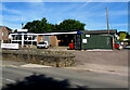
Thomas Brown Electrical Ltd, Wonastow Road, Monmouth
Electrical contractors located in the Old Filling Station, Wonastow Road.
Image: © Jaggery
Taken: 12 Jul 2020
0.02 miles
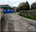
2
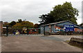
Drybridge Garage, Monmouth
Set back from the north side of Wonastow Road.
Image: © Jaggery
Taken: 26 Oct 2014
0.03 miles
3
Drybridge Garage, Wonastow Road, Monmouth
Set back from the north side of Wonastow Road.
Image: © Jaggery
Taken: 12 Jul 2020
0.03 miles
4
Thomas Brown (electrical contractors) premises and van, Monmouth
Thomas Brown Electrical Ltd is located in the Old Filling Station, viewed from Wonastow Road in July 2020.
Image: © Jaggery
Taken: 12 Jul 2020
0.03 miles
5
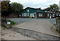
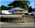
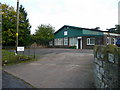
Drybridge Veterinary Clinic, Monmouth
From Williams Field Lane, near the corner of Wonastow Road.
Image: © Jaggery
Taken: 26 Oct 2014
0.03 miles
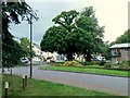
6
Williams Field Lane, Monmouth
Cul-de-sac viewed across Wonastow Road in July 2020.
The bilingual sign on the left shows that Williams Field Lane is Lôn Maes William in Welsh.
The arrow on the sign on the right points towards Drybridge Veterinary Clinic.
Image: © Jaggery
Taken: 12 Jul 2020
0.03 miles
7
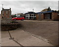
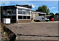
R&P Car Sales, Monmouth
Viewed from Wonastow Road in October 2014. The solitary car contrasts with the many cars in this forecourt in a Google Earth Street View taken in June 2011, when the nameboard showed Monmouth Car Centre.
Image: © Jaggery
Taken: 26 Oct 2014
0.04 miles
8
Drybridge Veterinery Clinic, Monmouth
This vet's premises is within the Overmonnow part of town.
Image: © Jonathan Billinger
Taken: 24 Oct 2008
0.04 miles
9
Road to Care Facilities
This is the access road to the Monnow Vale Health and Social Care Facility, with associated sheltered housing.
Image: © Jonathan Billinger
Taken: 11 Sep 2018
0.04 miles
10
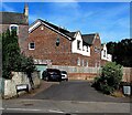
Williams Field Lane, Monmouth
Viewed from Wonastow Road in October 2014, when Bowen Gardens house
construction is in progress on the site of the demolished Trevor Bowen Court.
Image: © Jaggery
Taken: 26 Oct 2014
0.04 miles