IMAGES TAKEN NEAR TO
Wonastow Road, MONMOUTH, NP25 5AH
Introduction
This page details the photographs taken nearby to Wonastow Road, NP25 5AH by members of the Geograph project.
The Geograph project started in 2005 with the aim of publishing, organising and preserving representative images for every square kilometre of Great Britain, Ireland and the Isle of Man.

There are currently over 7.5m images from over14,400 individuals and you can help contribute to the project by visiting https://www.geograph.org.uk
Image Map
Images are licensed for reuse under creativecommons.org/licenses/by-sa/2.0
Notes
- Clicking on the map will re-center to the selected point.
- The higher the marker number, the further away the image location is from the centre of the postcode.
Image Listing (526 Images Found)
Images are licensed for reuse under creativecommons.org/licenses/by-sa/2.0
Image
Details
Distance
1
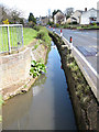
Water draining northeast to join the River Monnow
Running along the north side of Wonastow Road. Ahead it is culverted under the road, emerging on the south side.
Image: © Pauline E
Taken: 7 Apr 2009
0.00 miles
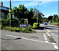
2
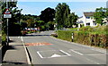
Warning sign - Patrol/Hebryngwr, Wonastow Road, Monmouth
English/Welsh sign near speed bumps/humps on Wonastow Road.
Image: © Jaggery
Taken: 12 Jul 2020
0.01 miles
3
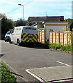
Molson Green van, Victoria Court, Monmouth
Volkswagen van viewed from the corner of Wonastow Road in July 2020.
Image: © Jaggery
Taken: 12 Jul 2020
0.02 miles
4
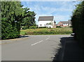
NW end of Fitzroy Close, Monmouth
Looking towards Wonastow Road in July 2020.
Image: © Jaggery
Taken: 12 Jul 2020
0.02 miles
5
Hedges and houses in Fitzroy Close, Monmouth
Viewed from Wonastow Road.
Image: © Jaggery
Taken: 26 Oct 2014
0.02 miles
6
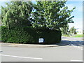
Green corner of Monmouth
Trees and hedge on the corner of Fitzroy Close and Wonastow Road viewed in July 2020.
Image: © Jaggery
Taken: 12 Jul 2020
0.02 miles
7
Junction of Victoria Court and Wonastow Road, Monmouth
From the left, dead-end Victoria Court joins Wonastow Road.
Image: © Jaggery
Taken: 12 Jul 2020
0.02 miles
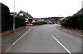
8
Three speed bumps across Wonastow Road, Monmouth
On the approach to the King's Fee junction.
Image: © Jaggery
Taken: 12 Jul 2020
0.03 miles
9
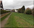
Path along the edge of Clawdd-du, Overmonnow, Monmouth
Clawdd-du is the ditch which once provided the outer defences of the faubourg of Overmonnow.
A faubourg was the area just beyond the town walls. The waters of the River Monnow could be diverted through here in times of threat. Medieval Clawdd-du Bridge http://www.geograph.org.uk/photo/4274969 is nearby.
Image: © Jaggery
Taken: 26 Oct 2014
0.03 miles
10
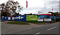
Bowen Gardens construction site in Monmouth
Viewed in late October 2014, this is the Wonastow Road and Kings Fee
corner of a Capsel and Lovell development of two and three bedroom houses.
Image: © Jaggery
Taken: 26 Oct 2014
0.03 miles