IMAGES TAKEN NEAR TO
Trelleck, MONMOUTH, NP25 4UA
Introduction
This page details the photographs taken nearby to NP25 4UA by members of the Geograph project.
The Geograph project started in 2005 with the aim of publishing, organising and preserving representative images for every square kilometre of Great Britain, Ireland and the Isle of Man.

There are currently over 7.5m images from over14,400 individuals and you can help contribute to the project by visiting https://www.geograph.org.uk
Image Map (Loading...)


Getting Data...Please wait
Leaflet Map data © OpenStreetMap
Images are licensed for reuse under creativecommons.org/licenses/by-sa/2.0
Notes
- Clicking on the map will re-center to the selected point.
- The higher the marker number, the further away the image location is from the centre of the postcode.
Image Listing (2 Images Found)
Images are licensed for reuse under creativecommons.org/licenses/by-sa/2.0
Image
Details
Distance
1
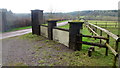
Private drive, public footpath
Leading to Loysey which seems to be completely surrounded by Loysey Wood.
Image: © Jonathan Billinger
Taken: 25 Jan 2016
0.21 miles
2

Wetmeadow Wood
The going underfoot leads to the aptly named woodland north of Redbarn Farm.
Image: © Jonathan Billinger
Taken: 14 Feb 2007
0.24 miles