IMAGES TAKEN NEAR TO
Llandogo, MONMOUTH, NP25 4TP
Introduction
This page details the photographs taken nearby to NP25 4TP by members of the Geograph project.
The Geograph project started in 2005 with the aim of publishing, organising and preserving representative images for every square kilometre of Great Britain, Ireland and the Isle of Man.

There are currently over 7.5m images from over14,400 individuals and you can help contribute to the project by visiting https://www.geograph.org.uk
Image Map
Images are licensed for reuse under creativecommons.org/licenses/by-sa/2.0
Notes
- Clicking on the map will re-center to the selected point.
- The higher the marker number, the further away the image location is from the centre of the postcode.
Image Listing (87 Images Found)
Images are licensed for reuse under creativecommons.org/licenses/by-sa/2.0
Image
Details
Distance
1
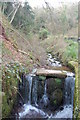
Man-made waterfall at Llandogo
This stream rising in the nearby Cleddon area falls steeply through woods into the river Wye at the village of Llandogo. It appears likely that waterpower was harnessed at this point although little of the original structure remains. Llandogo is probably most famous for ship building. The "Llandogger Trow" pub in central Bristol recalls the time when flat-bottomed trows built in Llandogo sailed the rivers Wye and Severn.
Image: © Roger Davies
Taken: 19 Mar 2008
0.09 miles
2
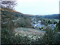
River Wye at Llandogo in early spring
This view of the River Wye looks upstream from the village of Llandogo. The route of the old Chepstow to Monmouth railway is in the centre of the photo to the right of St Oedoceus church. The A466 which passes through the village is also visible on the left.
Image: © Roger Davies
Taken: 19 Mar 2008
0.10 miles
3
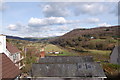
Llandogo
The village sits on the steep western side of the Wye valley gorge.
View from the south on a winter morning as the sun reaches the hill tops beyond.
Image: © Jonathan Billinger
Taken: 17 Dec 2010
0.12 miles
4
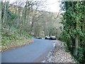
The Glyn
Road in the wooded slopes above Llandogo.
Image: © Jonathan Billinger
Taken: 17 Dec 2010
0.12 miles
5
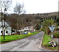
Road to Cleddon and Trelleck from Llandogo
Viewed across the A466. A sign behind the camera shows that Trelleck (also spelt Trellech) is 2½ miles away.
Image: © Jaggery
Taken: 4 Dec 2011
0.12 miles
6
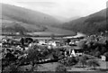
Llandogo Village from hillside
Taken in 1964 from 'The Priory' when the establishment was a centre run by the Holiday Fellowship. Image shows Llandogo village with church of St Oudoceus visible on left. Bend in River Wye in mid-distance.
Image: © Clint Mann
Taken: Unknown
0.13 miles
7
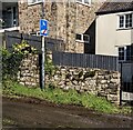
Ignore Satnav sign, Llandogo, Monmouthshire
Facing the A466, the main road through the village, the wordless sign is alongside a narrow lane.
HGV drivers who are directed along this lane should ignore their satnav.
Image: © Jaggery
Taken: 3 Mar 2024
0.14 miles
8
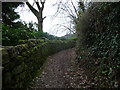
Hillside path in Llandogo
A curving and rising walled pathway makes its way up the steepish valley side. One of a network of old paths in and around this village.
Image: © Jeremy Bolwell
Taken: 24 Feb 2013
0.15 miles
9
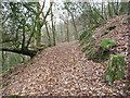
Part of the zig-zag path below Cleddon Shoots above Llandogo
These zig-zag paths were I believe laid out here in the 19th century for the growing numbers of tourists visiting the Lower Wye Valley.
Today the paths here are still very pleasant all year round - in autumn crisp golden leaves coat the paths, in spring new growth and birdsong prevail, in summer leafy veils and welcome shade and in winter clear views and empty woods can be enjoyed. The height is gained very steadily so all members of the family can gain the valley top without it becoming a climb.
Image: © Jeremy Bolwell
Taken: 24 Feb 2013
0.15 miles
10
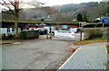
Llandogo Primary School
Located at the western end of Holmfield Drive, next to the Millennium Hall. http://www.geograph.org.uk/photo/2719997
Image: © Jaggery
Taken: 4 Dec 2011
0.15 miles