IMAGES TAKEN NEAR TO
Llandogo, MONMOUTH, NP25 4TH
Introduction
This page details the photographs taken nearby to NP25 4TH by members of the Geograph project.
The Geograph project started in 2005 with the aim of publishing, organising and preserving representative images for every square kilometre of Great Britain, Ireland and the Isle of Man.

There are currently over 7.5m images from over14,400 individuals and you can help contribute to the project by visiting https://www.geograph.org.uk
Image Map
Images are licensed for reuse under creativecommons.org/licenses/by-sa/2.0
Notes
- Clicking on the map will re-center to the selected point.
- The higher the marker number, the further away the image location is from the centre of the postcode.
Image Listing (13 Images Found)
Images are licensed for reuse under creativecommons.org/licenses/by-sa/2.0
Image
Details
Distance
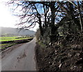
1
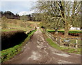
Access road to Pilstone Farm House near Whitebrook
From the minor road from the A466 to Whitebrook.
Image: © Jaggery
Taken: 1 Feb 2015
0.04 miles
2
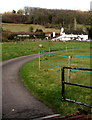
Entrance drive to Pilstone House near Whitebrook
From a minor road south of Whitebrook.
Image: © Jaggery
Taken: 1 Feb 2015
0.06 miles
3
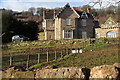
Pilstone House near Whitebrook
Viewed over a stone wall at the edge of a minor road south of Whitebrook.
Image: © Jaggery
Taken: 1 Feb 2015
0.06 miles
4
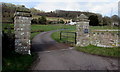
Grid across the entrance to Pilstone House near Whitebrook
From the minor road from the A466 to Whitebrook.
Image: © Jaggery
Taken: 1 Feb 2015
0.07 miles
5
Passing place opposite a partially collapsed wall south of Whitebrook
Alongside a minor road from Whitebrook to the A466.
Image: © Jaggery
Taken: 1 Feb 2015
0.09 miles
6
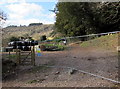
Keep out - construction site south of Whitebrook
Viewed from a minor road from Whitebrook to the A466.
Fencing prevents vehicles accessing the site, though the side gate is unlocked.
Image: © Jaggery
Taken: 1 Feb 2015
0.12 miles
8
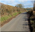
Passing place on the Whitebrook road
The narrow minor road north from the A466 to Whitebrook is not wide enough in many parts for two vehicles to pass each other. Here, a slight widening of the roadway on the right is enough for most vehicles to pass each other. I wondered what the rules of the road are when two wider than average vehicles approach each other on either side of the passing place...
Image: © Jaggery
Taken: 1 Feb 2015
0.15 miles
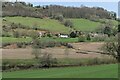
9
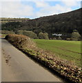
Gap in a field hedge south of Whitebrook
The field is on the west bank of the River Wye in Monmouthshire, Wales
The distant white buildings are on the east bank of the Wye, in Gloucestershire, England.
Image: © Jaggery
Taken: 1 Feb 2015
0.17 miles
10
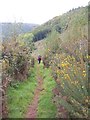
Struggling up the hillside
A walker on the steep path that ascends the hillside above the River Wye near Pilstone Farm.
Image: © Gordon Hatton
Taken: 17 Oct 2011
0.17 miles