IMAGES TAKEN NEAR TO
Garthi Close, MONMOUTH, NP25 4JN
Introduction
This page details the photographs taken nearby to Garthi Close, NP25 4JN by members of the Geograph project.
The Geograph project started in 2005 with the aim of publishing, organising and preserving representative images for every square kilometre of Great Britain, Ireland and the Isle of Man.

There are currently over 7.5m images from over14,400 individuals and you can help contribute to the project by visiting https://www.geograph.org.uk
Image Map
Images are licensed for reuse under creativecommons.org/licenses/by-sa/2.0
Notes
- Clicking on the map will re-center to the selected point.
- The higher the marker number, the further away the image location is from the centre of the postcode.
Image Listing (6 Images Found)
Images are licensed for reuse under creativecommons.org/licenses/by-sa/2.0
Image
Details
Distance
1

Moon over countryside
View over Lydart, Mitchell Troy to the Brecon Beacons
Image: © Jessica Aidley
Taken: 24 Jan 2005
0.07 miles
2
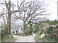
Mitcheltroy Common
One of the very steep roads above Mitchel Troy.
Image: © Richard Webb
Taken: 21 Mar 2022
0.09 miles
3
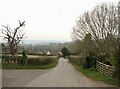
Road junction, Mitchel Troy
Road junction above the village of Mitchel Troy.
Image: © Philip Halling
Taken: 10 Oct 2010
0.13 miles
4
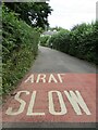
ARAF SLOW
A highlighted dual language warning on the road for motorists on this narrow lane in Mitchel Troy.
Image: © Colin Smith
Taken: 3 Aug 2023
0.14 miles
5
Mitchel Troy Common
This hillside community overlooks the Trothy valley to the north. This is a 20% gradient, or 1 in 5 in old money.
Image: © Jonathan Billinger
Taken: 29 Jan 2007
0.16 miles
6
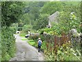
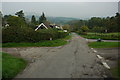
Mitcheltroy Common
Country lane with stone walls and scattered housing in this hillside hamlet.
Image: © Colin Smith
Taken: 3 Aug 2023
0.21 miles