IMAGES TAKEN NEAR TO
Cwmcarvan, MONMOUTH, NP25 4JL
Introduction
This page details the photographs taken nearby to NP25 4JL by members of the Geograph project.
The Geograph project started in 2005 with the aim of publishing, organising and preserving representative images for every square kilometre of Great Britain, Ireland and the Isle of Man.

There are currently over 7.5m images from over14,400 individuals and you can help contribute to the project by visiting https://www.geograph.org.uk
Image Map
Images are licensed for reuse under creativecommons.org/licenses/by-sa/2.0
Notes
- Clicking on the map will re-center to the selected point.
- The higher the marker number, the further away the image location is from the centre of the postcode.
Image Listing (4 Images Found)
Images are licensed for reuse under creativecommons.org/licenses/by-sa/2.0
Image
Details
Distance

2
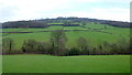
The Green fields of Monmouthshire
The colour of the grass is much more like March than January.
Image: © Jonathan Billinger
Taken: 25 Jan 2016
0.17 miles
3
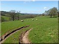
Sheep grazing near Brook Farm
Sheep grazing near Brook Farm, Skirrid and the Black Mountains can be seen in the distance.
Image: © Philip Halling
Taken: 6 Apr 2017
0.17 miles
4
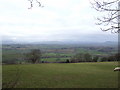
Craig-y-dorth; view due west
This panorama takes in the hills (left to right); Blorenge, Ysgyryd Fach, Sugarloaf, Ysgyryd Fawr, Pen y Gadair Fawr, Waun Fach, Hay Bluff, and the much closer hill at Edmunds Tump. The high tops of the Beacons can be seen on clearer days behind the Sugarloaf.
Image: © Jonathan Billinger
Taken: 29 Jan 2007
0.20 miles