IMAGES TAKEN NEAR TO
Dingestow, MONMOUTH, NP25 4BQ
Introduction
This page details the photographs taken nearby to NP25 4BQ by members of the Geograph project.
The Geograph project started in 2005 with the aim of publishing, organising and preserving representative images for every square kilometre of Great Britain, Ireland and the Isle of Man.

There are currently over 7.5m images from over14,400 individuals and you can help contribute to the project by visiting https://www.geograph.org.uk
Image Map
Images are licensed for reuse under creativecommons.org/licenses/by-sa/2.0
Notes
- Clicking on the map will re-center to the selected point.
- The higher the marker number, the further away the image location is from the centre of the postcode.
Image Listing (13 Images Found)
Images are licensed for reuse under creativecommons.org/licenses/by-sa/2.0
Image
Details
Distance
1
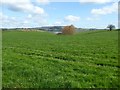
Farmland around The Bourne
Farmland surrounding The Bourne near Dingestow.
Image: © Philip Halling
Taken: 6 Apr 2017
0.11 miles
2
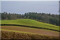
Mitchel Troy : Countryside Scenery
Looking across the fields from the A40
Image: © Lewis Clarke
Taken: 22 Mar 2023
0.17 miles
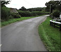
3
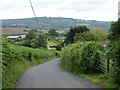
Downhill view
Almost at the foot of the hill on leaving Pen-y-clawdd.
Image: © Ian Paterson
Taken: 21 Jun 2011
0.18 miles
4
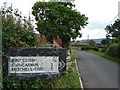
The old ones are the best
Old but still going strong. Old roadsign at the foot of the hill.
Image: © Ian Paterson
Taken: 21 Jun 2011
0.19 miles
5
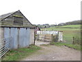
Farm buildings near Lower Tre-fal-du
Trefaldu is the venue for a coarse fishing business.
Image: © Jonathan Billinger
Taken: 29 Jan 2007
0.20 miles
6
Minor road towards Pen-y-Clawdd and Llansoy, Monmouthshire
Pointing ahead, a sign https://www.geograph.org.uk/photo/5888096 behind the camera shows Pen-y-Clawdd 1 (mile), Llansoy 6.
This is also the way to Trefaldu Coarse Fishery and a camping & caravan site.
Image: © Jaggery
Taken: 27 Aug 2018
0.20 miles
7
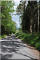
Road through Bourne Wood
This road passes through Bourne Wood, from Dingestow to Pen-y-clawdd.
Image: © Philip Halling
Taken: 14 May 2011
0.21 miles
8
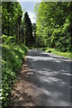
Road to Pen-y-clawdd
Road to Pen-y-clawdd passing through Bourne Wood.
Image: © Philip Halling
Taken: 14 May 2011
0.23 miles
9
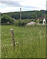
Grassy field south of Dingestow, Monmouthshire
The road in the background leads to Pen-y-Clawdd and Llansoy.
Image: © Jaggery
Taken: 9 Jun 2024
0.23 miles
10
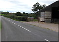
Unclassified road from Monmouth towards Raglan
Nearby signs https://www.geograph.org.uk/photo/5888090 show Raglan 4 (miles), Monmouth 4½
This unclassified road was formerly part of the A40 which now uses
a nearby former railway route through this part of rural Monmouthshire.
A farm building https://www.geograph.org.uk/photo/5888070 is on the right.
Image: © Jaggery
Taken: 27 Aug 2018
0.23 miles