IMAGES TAKEN NEAR TO
Alders Drive, MONMOUTH, NP25 4AZ
Introduction
This page details the photographs taken nearby to Alders Drive, NP25 4AZ by members of the Geograph project.
The Geograph project started in 2005 with the aim of publishing, organising and preserving representative images for every square kilometre of Great Britain, Ireland and the Isle of Man.

There are currently over 7.5m images from over14,400 individuals and you can help contribute to the project by visiting https://www.geograph.org.uk
Image Map
Images are licensed for reuse under creativecommons.org/licenses/by-sa/2.0
Notes
- Clicking on the map will re-center to the selected point.
- The higher the marker number, the further away the image location is from the centre of the postcode.
Image Listing (120 Images Found)
Images are licensed for reuse under creativecommons.org/licenses/by-sa/2.0
Image
Details
Distance
1
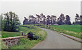
Dingestow: site/remains of former station, 1990
View southward, with probable station house in the trees: ex-GWR Monmouth Troy (to left) - Pontypool Road (to right) line, closed completely 13/6/55.
Image: © Ben Brooksbank
Taken: 21 May 1990
0.01 miles
2
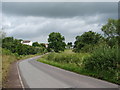
Almost in Dingestow
On the outskirts of the village approaching from the south.
Image: © Ian Paterson
Taken: 21 Jun 2011
0.04 miles
3
Southern boundary of Dingestow
The Dingestow (Llanddingad in Welsh) sign is alongside the road from Monmouth Road, just north of the A40 bridge. http://www.geograph.org.uk/photo/2391130
Image: © Jaggery
Taken: 1 May 2011
0.05 miles
4
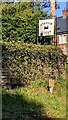
Station House name sign, Dingestow
At the SE edge of the Monmouthshire village viewed in May 2024.
Dingestow has not had a railway service for nearly 70 years.
Dingestow Station closed in 1955.
Image: © Jaggery
Taken: 5 May 2024
0.05 miles
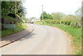
5
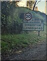
From 30 to 20 at the SE edge of Dingestow, Monmouthshire
The 30mph speed limit drops to 20mph. The village name
sign shows that Dingestow is Llanddingad in Welsh.
Image: © Jaggery
Taken: 5 May 2024
0.06 miles

7
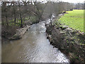
River Trothy, view downstream
The course of the river soon swings east towards its confluence with the Wye, south of Monmouth.
Image: © Pauline E
Taken: 20 Feb 2009
0.09 miles
8
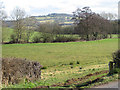
View Southeast from Dingestow
The A40 is hidden from view. Craig-y-dorth rises to 243m.
Image: © Pauline E
Taken: 20 Feb 2009
0.09 miles
9
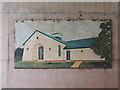
Mural 5
Fifth of five murals under the bridge. This one is the refurbished village hall.
Image: © Ian Paterson
Taken: 21 Jun 2011
0.09 miles
10
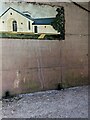
Village hall mural, Dingestow, Monmouthshire
This Dingestow Village Hall https://www.geograph.org.uk/photo/7794127 depiction is one of several murals below
the bridge carrying the A40 over a minor road in the south of Dingestow.
Image: © Jaggery
Taken: 9 Jun 2024
0.09 miles