IMAGES TAKEN NEAR TO
Redbrook Road, MONMOUTH, NP25 3LZ
Introduction
This page details the photographs taken nearby to Redbrook Road, NP25 3LZ by members of the Geograph project.
The Geograph project started in 2005 with the aim of publishing, organising and preserving representative images for every square kilometre of Great Britain, Ireland and the Isle of Man.

There are currently over 7.5m images from over14,400 individuals and you can help contribute to the project by visiting https://www.geograph.org.uk
Image Map
Images are licensed for reuse under creativecommons.org/licenses/by-sa/2.0
Notes
- Clicking on the map will re-center to the selected point.
- The higher the marker number, the further away the image location is from the centre of the postcode.
Image Listing (91 Images Found)
Images are licensed for reuse under creativecommons.org/licenses/by-sa/2.0
Image
Details
Distance
1
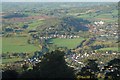
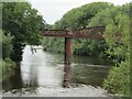
Monmouth - Old Railways
Brick Viaduct and Metal Bridge on left hand part of picture
Image: © Peter Randall-Cook
Taken: 17 Oct 2007
0.04 miles
2
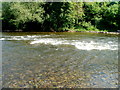
A white water section of the River Wye, Monmouth
The white water, visible on satellite views, appears to be a permanent feature of this part of the River Wye, between a former railway bridge http://www.geograph.org.uk/photo/3356672 and the stonework http://www.geograph.org.uk/photo/3356858 of a former railway viaduct.
Image: © Jaggery
Taken: 2 May 2011
0.04 miles
3
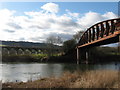
Former railway bridge and viaduct, River Wye, Monmouth
Image: © Gareth James
Taken: 22 Feb 2009
0.05 miles
4
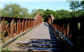
Across the Duke of Beaufort bridge, Monmouth
Now a footbridge over the River Wye, the Duke of Beaufort railway bridge was opened in 1874 to connect Monmouth Mayhill station on the east side of the Wye with Monmouth Troy station on the west side. Passenger services at both stations ceased in 1959. http://www.geograph.org.uk/photo/3356672 to a view from the riverbank.
Image: © Jaggery
Taken: 2 May 2011
0.06 miles
5
Monmouth - Former Railway Bridge
Spanning the River Wye south of Monmouth town is the Duke of Beaufort Railway Bridge. It was opened in 1874 connecting Monmouth Mayhill with Monmouth Troy stations. Passenger services ceased in 1959 but the bridge today (2023) is still open to pedestrians.
www.wyevalleyaonb.org.uk
Image: © Colin Smith
Taken: 4 Aug 2023
0.06 miles
6
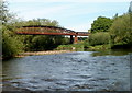
Duke of Beaufort bridge, Monmouth
Now a footbridge over the River Wye, the Duke of Beaufort railway bridge was opened in 1874 to connect Monmouth Mayhill station on the east side of the Wye with Monmouth Troy station on the west side. Passenger services at both stations ceased in 1959.
http://www.geograph.org.uk/photo/3356678 to a view across the bridge.
Image: © Jaggery
Taken: 2 May 2011
0.06 miles
7
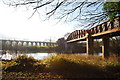
The bridges of Monmouthshire county
Railway bridges over the Wye at Monmouth. The cast iron bowstring bridge was on the line from Ross on Wye, while the viaduct to the left of the shot was on the Wye Valley line to Chepstow. Monmouth Troy station was at the junction between these two lines, but despite this there was never any real attempt to run them as a single branch line: one always had to change trains at Monmouth Troy and wait for a Wye Valley line train, possibly contributing to the pre - Beeching closure of both lines in January 1959.
Image: © John Winder
Taken: 3 Jan 2009
0.06 miles
8
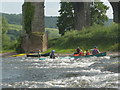
Wye rapid between bridges
There were two railway bridges over the Wye downstream from Monmouth, just below the confluence with the River Monnow (Afon Mynwy) which gives Monmouth its name. The second bridge, seen here, has now had the spans over the river dismantled, though it is still shown on maps. Between the viaducts is this short rapid with play potential. The kayaker is busy surfing the wave, whilst the Canadian with two adults and no less than four children is making its third descent of the bouncy waves river right, the beach beyond providing a convenient upstream portage for repeat descents. There aren't many rapids on this section of river, especially in low summer flows, so it's worth making the most of any you do come across !
Image: © Andy Waddington
Taken: 21 Jun 2003
0.06 miles
9
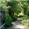
Footpath on the north side of the Duke of Beaufort bridge, Monmouth
The bridge http://www.geograph.org.uk/photo/3356678 over the River Wye was formerly a railway bridge between Monmouth Troy and Monmouth Mayhill stations. The footpath ahead follows the route that the railway formerly took towards Mayhill station, which closed in 1959.
Image: © Jaggery
Taken: 2 May 2011
0.06 miles
10
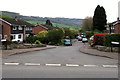
Ridgeway, Wyesham
Cul-de-sac on the south side of Wyesham Road.
Image: © Jaggery
Taken: 26 Apr 2015
0.07 miles