IMAGES TAKEN NEAR TO
Redbrook Road, MONMOUTH, NP25 3LY
Introduction
This page details the photographs taken nearby to Redbrook Road, NP25 3LY by members of the Geograph project.
The Geograph project started in 2005 with the aim of publishing, organising and preserving representative images for every square kilometre of Great Britain, Ireland and the Isle of Man.

There are currently over 7.5m images from over14,400 individuals and you can help contribute to the project by visiting https://www.geograph.org.uk
Image Map
Images are licensed for reuse under creativecommons.org/licenses/by-sa/2.0
Notes
- Clicking on the map will re-center to the selected point.
- The higher the marker number, the further away the image location is from the centre of the postcode.
Image Listing (148 Images Found)
Images are licensed for reuse under creativecommons.org/licenses/by-sa/2.0
Image
Details
Distance
1
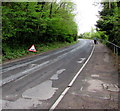
Uneven road surface sign, Wyesham Road, Monmouth
The triangular sign is temporary, suggesting the road will be resurfaced soon - perhaps!
Image: © Jaggery
Taken: 26 Apr 2015
0.03 miles
2
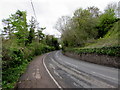
Wyesham Road towards Mayhill, Monmouth
The road descends from Wyesham towards Mayhill in the east of Monmouth.
Image: © Jaggery
Taken: 26 Apr 2015
0.03 miles
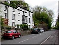
3
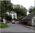
Redbrook Road houses adjacent to a former railway, Monmouth
These two semis are the only houses on the west side of Redbrook Road in this area. There was formerly a railway behind the houses, running parallel with Redbrook Road, between Monmouth Mayhill railway station to the north and Monmouth Troy railway station to the south. Though the stations closed decades ago and the track has long since been lifted, reminders of the railway remain in the shape of two nearby former railway bridges across the River Wye.
Image: © Jaggery
Taken: 2 May 2011
0.04 miles
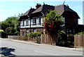
4
Heathdale and Greenbanks, Wyesham Road, Monmouth
Semi-detached houses near the Mayhill (northern) end of Wyesham Road.
Image: © Jaggery
Taken: 26 Apr 2015
0.04 miles
5
Wyesham Road, Mayhill, Monmouth
The road to Wyesham heads south away from the Mayhill area in the east of Monmouth.
Image: © Jaggery
Taken: 26 Apr 2015
0.05 miles
6
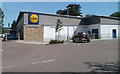
Lidl, Monmouth
Located alongside Redbrook Road (A466).
Image: © Jaggery
Taken: 2 May 2011
0.06 miles
7
Lidl's near Monmouth
View of Lidl's with the Kymin visible high above on the hill.
Image: © Stuart Wilding
Taken: 16 Mar 2014
0.06 miles
8
Mayhill Cottages, Monmouth
Set above Wyesham Road, on the south side of the Mayhill Hotel. http://www.geograph.org.uk/photo/4450805
Image: © Jaggery
Taken: 26 Apr 2015
0.06 miles
9
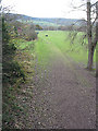
Route of dismantled railway, Monmouth
Taken from the bridge. From the other side of the bridge, the route is more difficult to trace due to the presence of buildings.
Image: © Pauline E
Taken: 22 Nov 2007
0.06 miles
10
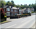
Sabrina Villas, Monmouth
Viewed across the A466 Redbrook Road. The two semi-detached houses nearest the camera are numbers 1 and 2 Sabrina Villas. I don't know the origin of this name. It could be a reference to Sabrina, the ancient Romans' name for the River Severn, though the connection with this location is not apparent, because that river is about 25 km south of here.
Image: © Jaggery
Taken: 2 May 2011
0.06 miles