IMAGES TAKEN NEAR TO
Monk Street, MONMOUTH, NP25 3LW
Introduction
This page details the photographs taken nearby to Monk Street, NP25 3LW by members of the Geograph project.
The Geograph project started in 2005 with the aim of publishing, organising and preserving representative images for every square kilometre of Great Britain, Ireland and the Isle of Man.

There are currently over 7.5m images from over14,400 individuals and you can help contribute to the project by visiting https://www.geograph.org.uk
Image Map
Images are licensed for reuse under creativecommons.org/licenses/by-sa/2.0
Notes
- Clicking on the map will re-center to the selected point.
- The higher the marker number, the further away the image location is from the centre of the postcode.
Image Listing (862 Images Found)
Images are licensed for reuse under creativecommons.org/licenses/by-sa/2.0
Image
Details
Distance
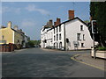
1
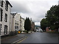
No parking at any time on Dixton Road, Monmouth
Double yellow lines on both sides of Dixton Road make parking
here illegal at any time. Viewed from the corner of Monk Street.
Image: © Jaggery
Taken: 26 Oct 2014
0.01 miles
2
Distances from Monmouth
Pointing left (east) along the A466 Dixton Road, a sign shows 11 (miles) to Ross(-on-Wye), 17 to Chepstow,
23 to Newport and 17 to Abergavenny. The sign below it shows a route to Hereford for heavy goods vehicles.
Image: © Jaggery
Taken: 26 Oct 2014
0.01 miles
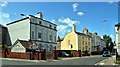
3
Buildings along North Parade (A466)
The road heads towards Hereford. Turn right to the A40 to Ross - turn left into Priory Street and Monmouth town centre.
Image: © Pauline E
Taken: 26 Oct 2009
0.02 miles
5
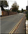
Monk Street, Monmouth
The main road out of town to Hereford. Very little changed in the past 100 years, there are a number of elegant late 18th and early 19th century houses on both sides, many of them used by the two major schools in the town.
Image: © Philip Pankhurst
Taken: 15 Jun 2017
0.02 miles
6
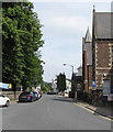
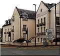
North along Monk Street, Monmouth
From Whitecross Street along Monk Street towards Dixton Road.
The trees on the left are at the edge of St Mary's churchyard.
Image: © Jaggery
Taken: 10 Jun 2018
0.02 miles
7
![Monmouth houses [35]](https://s1.geograph.org.uk/geophotos/06/93/78/6937817_1ae4b886_120x120.jpg)
Monmouth houses [35]
Number 7 Monk Street is in two parts. The right part, seen here, is later 19th century, possibly incorporating an earlier, 17th century, structure. The left part, seen at Image is early 19th century. It would seem that the house has been divided with the left part now advertised as a holiday cottage. The right part is rendered and painted brick with a Welsh slate roof. The left part is roughcast stone with a concealed roof. Listed, grade II, with details at: https://cadwpublic-api.azurewebsites.net/reports/listedbuilding/FullReport?lang=&id=2283
Monmouth is a market town at the confluence of the Rivers Monnow and Wye some 30 miles northeast of Cardiff. Although there is evidence of settlement in the Neolithic period, the town was established around the Norman castle which was the birthplace of King Henry V. The historic county town of Monmouthshire, the town is now a centre for Wye Valley tourism.
Image: © Michael Dibb
Taken: 28 May 2021
0.02 miles
8
![Monmouth houses [36]](https://s1.geograph.org.uk/geophotos/06/93/78/6937821_f0ab5b79_120x120.jpg)
Monmouth houses [36]
Number 7 Monk Street is in two parts. The left part, seen here, is early 19th century. The right part, seen at Image, is later 19th century, possibly incorporating an earlier, 17th century, structure. It would seem that the house has been divided with the left part now advertised as a holiday cottage. The right part is rendered and painted brick with a Welsh slate roof. The left part is roughcast stone with a concealed roof. Listed, grade II, with details at: https://cadwpublic-api.azurewebsites.net/reports/listedbuilding/FullReport?lang=&id=2283
Monmouth is a market town at the confluence of the Rivers Monnow and Wye some 30 miles northeast of Cardiff. Although there is evidence of settlement in the Neolithic period, the town was established around the Norman castle which was the birthplace of King Henry V. The historic county town of Monmouthshire, the town is now a centre for Wye Valley tourism.
Image: © Michael Dibb
Taken: 28 May 2021
0.02 miles
9
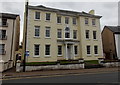
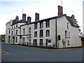
Elegant Georgian house in Monk Street, Monmouth
Built in 1737 during the reign of King George II, the 3-storey Royal George House
has Corinthian pillars at the entrance. The building has been divided into flats.
Image: © Jaggery
Taken: 26 Oct 2014
0.03 miles