IMAGES TAKEN NEAR TO
Hillcrest Road, MONMOUTH, NP25 3LJ
Introduction
This page details the photographs taken nearby to Hillcrest Road, NP25 3LJ by members of the Geograph project.
The Geograph project started in 2005 with the aim of publishing, organising and preserving representative images for every square kilometre of Great Britain, Ireland and the Isle of Man.

There are currently over 7.5m images from over14,400 individuals and you can help contribute to the project by visiting https://www.geograph.org.uk
Image Map
Images are licensed for reuse under creativecommons.org/licenses/by-sa/2.0
Notes
- Clicking on the map will re-center to the selected point.
- The higher the marker number, the further away the image location is from the centre of the postcode.
Image Listing (98 Images Found)
Images are licensed for reuse under creativecommons.org/licenses/by-sa/2.0
Image
Details
Distance
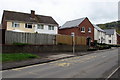
1
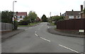
Hillcrest Road, Wyesham
From Wyesham Road. The name sign on the right shows that Hillcrest Road leads to several cul-de-sacs.
Image: © Jaggery
Taken: 26 Apr 2015
0.02 miles
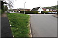
2
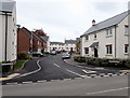
Old School Lane, Wyesham
Houses built in the second decade of the 21st century in a cul-de-sac on the north side of Wyesham Road.
Image: © Jaggery
Taken: 26 Apr 2015
0.04 miles
3
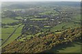
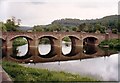
Wyesham
Wyesham in the foreground with Monmouth in the middle distance
Image: © Peter Randall-Cook
Taken: 31 Oct 2010
0.05 miles
6
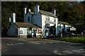
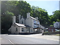
Mayhill Hotel, Monmouth
The Mayhill Hotel on the side of the A4136 at May Hill, Monmouth.
Image: © Philip Halling
Taken: 4 Nov 2007
0.07 miles
7
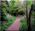
Path through a small wood, Wyesham
From Wyesham Road near Old School Lane. http://www.geograph.org.uk/photo/4447770
Image: © Jaggery
Taken: 26 Apr 2015
0.07 miles
9
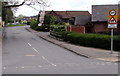
Wyesham Road bus stop near Old School Lane, Wyesham
The turning for recently-built Old School Lane http://www.geograph.org.uk/photo/4447770 is ahead.
Image: © Jaggery
Taken: 26 Apr 2015
0.08 miles
10
Junction of Justin's Hill and Highmeadow, Wyesham
Viewed from Justin's Hill which continues on the left. Highmeadow is on the right.
Image: © Jaggery
Taken: 26 Apr 2015
0.08 miles