IMAGES TAKEN NEAR TO
Duchess Road, MONMOUTH, NP25 3HT
Introduction
This page details the photographs taken nearby to Duchess Road, NP25 3HT by members of the Geograph project.
The Geograph project started in 2005 with the aim of publishing, organising and preserving representative images for every square kilometre of Great Britain, Ireland and the Isle of Man.

There are currently over 7.5m images from over14,400 individuals and you can help contribute to the project by visiting https://www.geograph.org.uk
Image Map
Images are licensed for reuse under creativecommons.org/licenses/by-sa/2.0
Notes
- Clicking on the map will re-center to the selected point.
- The higher the marker number, the further away the image location is from the centre of the postcode.
Image Listing (13 Images Found)
Images are licensed for reuse under creativecommons.org/licenses/by-sa/2.0
Image
Details
Distance
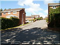
2
Prospect Road, Osbaston
Detached houses in the northern suburb of Monmouth, looking south.
Image: © Jonathan Billinger
Taken: 14 Jul 2009
0.13 miles
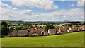
3
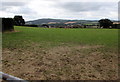
Berryfield Park houses, Monmouth
Looking across a field towards houses in Berryfield Park.
Viewed from the T-junction of Oakfield Road and Agincourt Road.
Image: © Jaggery
Taken: 22 Oct 2011
0.16 miles
4
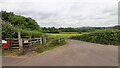
Footpath from Osbaston Road
Over one field to Forge Road and the Monnow.
Image: © Jonathan Billinger
Taken: 21 Jun 2021
0.18 miles
5
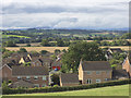
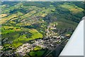
View west from Agincourt Road, 2020
An autumnal revisit to the same spot as in Image taken in August 2019.
With some telephoto the outline of Skirrid with the very top of Sugarloaf can be seen as well as Pen y Gadair Fawr far right distance.
The edge of Monmouth's Osbaston suburb in the foreground.
Image: © Jonathan Billinger
Taken: 23 Sep 2020
0.20 miles
6
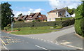
Osbaston : corner of Osbaston Road and Chaucer Way
Viewed across Osbaston Road.
Image: © Jaggery
Taken: 12 Sep 2010
0.20 miles
7
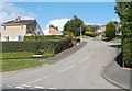
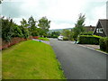
Chaucer Way, Osbaston
Chaucer Way climbs away from Osbaston Road.
Image: © Jaggery
Taken: 12 Sep 2010
0.20 miles
8
View towards Osbaston, Monmouth
From a Hereford Road field gate towards houses at the northeast edge of Osbaston.
Image: © Jaggery
Taken: 21 Aug 2016
0.20 miles
9
Lancaster Way, Osbaston
At the western edge of residential Osbaston, Lancaster Way climbs away from Osbaston Road.
Image: © Jaggery
Taken: 12 Sep 2010
0.21 miles
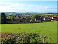
10
View west from Agincourt Road
Beyond the housing estates of Osbaston, the hills of Monmouthshire can be seen including The Skirrid and St. Edmunds Tump.
Image: © Jonathan Billinger
Taken: 20 Aug 2019
0.21 miles