IMAGES TAKEN NEAR TO
Hereford Road, MONMOUTH, NP25 3HJ
Introduction
This page details the photographs taken nearby to Hereford Road, NP25 3HJ by members of the Geograph project.
The Geograph project started in 2005 with the aim of publishing, organising and preserving representative images for every square kilometre of Great Britain, Ireland and the Isle of Man.

There are currently over 7.5m images from over14,400 individuals and you can help contribute to the project by visiting https://www.geograph.org.uk
Image Map
Images are licensed for reuse under creativecommons.org/licenses/by-sa/2.0
Notes
- Clicking on the map will re-center to the selected point.
- The higher the marker number, the further away the image location is from the centre of the postcode.
Image Listing (39 Images Found)
Images are licensed for reuse under creativecommons.org/licenses/by-sa/2.0
Image
Details
Distance
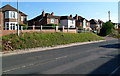
1
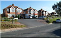
Hereford Road semis, Monmouth
Semi-detached houses on the east side of the A466. The elevated pavement briefly descends to road level here to allow vehicles access to the houses.
Image: © Jaggery
Taken: 22 Oct 2011
0.01 miles
2
Speed camera warning sign, Hereford Road, Monmouth
Facing southbound traffic on the A466 Hereford Road.
Image: © Jaggery
Taken: 21 Aug 2016
0.01 miles
3
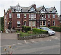
Row of four houses, Hereford Road, Monmouth
The front door of the house on the right is set back slightly, here out of shot.
Image: © Jaggery
Taken: 21 Aug 2016
0.03 miles
4
Hereford Road semis, Monmouth
Semi-detached houses set back from, and slightly above, the east side of the A466 Hereford Road.
Image: © Jaggery
Taken: 21 Aug 2016
0.04 miles
5
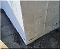
Ordnance Survey Cut Mark
This OS cut mark can be found on No49 Hereford Road. It marks a point 60.984m above mean sea level.
Image: © Adrian Dust
Taken: 30 Jan 2019
0.04 miles
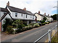
6

West side of Hereford Road, Monmouth
Houses on the west side of the A466 Hereford Road, south of The Vineyard
junction, viewed from the elevated pavement on the east side of the road.
Image: © Jaggery
Taken: 21 Aug 2016
0.04 miles
7
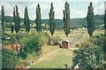
Wye valley in summer
View from the same point as Image, the Wye valley in the distance, suburban gardens in the foreground.
Image: © Jonathan Billinger
Taken: Unknown
0.06 miles
8
Hereford Road houses, Monmouth
Houses on the west side of the A466 Hereford Road, south of The Vineyard
junction, viewed from the elevated pavement on the east side of the road.
Image: © Jaggery
Taken: 21 Aug 2016
0.06 miles
9
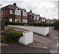
Elevated pavement above Hereford Road, Monmouth
Above the east side of the A466 Hereford Road.
Image: © Jaggery
Taken: 21 Aug 2016
0.07 miles
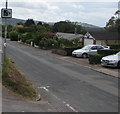
10
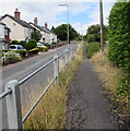
Up-and-down course of elevated pavement, Hereford Road, Monmouth
At intervals, the elevated pavement along the eastern edge of Hereford Road (A466) descends to road level to allow vehicular access to houses. This section is near the junction of Hereford Road and The Vineyard, just behind the camera.
Image: © Jaggery
Taken: 22 Oct 2011
0.08 miles