IMAGES TAKEN NEAR TO
Granville Street, MONMOUTH, NP25 3DR
Introduction
This page details the photographs taken nearby to Granville Street, NP25 3DR by members of the Geograph project.
The Geograph project started in 2005 with the aim of publishing, organising and preserving representative images for every square kilometre of Great Britain, Ireland and the Isle of Man.

There are currently over 7.5m images from over14,400 individuals and you can help contribute to the project by visiting https://www.geograph.org.uk
Image Map
Images are licensed for reuse under creativecommons.org/licenses/by-sa/2.0
Notes
- Clicking on the map will re-center to the selected point.
- The higher the marker number, the further away the image location is from the centre of the postcode.
Image Listing (758 Images Found)
Images are licensed for reuse under creativecommons.org/licenses/by-sa/2.0
Image
Details
Distance
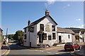
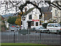
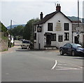
2
Granville Street, Monmouth
Viewed across Old Dixton Road. The Old Nags Head http://www.geograph.org.uk/photo/4227966 is on the left.
Image: © Jaggery
Taken: 26 Oct 2014
0.01 miles
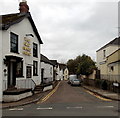
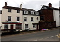
3
The Old Nags Head, Monmouth
Pub on the corner of Old Dixton Road and Granville Street.
The pub sign artist has created a cute image of an old nag (a horse not a scold!) http://www.geograph.org.uk/photo/4227975
There is no apostrophe in any of several instances of the pub's name in view.
Image: © Jaggery
Taken: 26 Oct 2014
0.02 miles
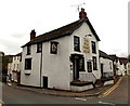
5
![Monmouth buildings [46]](https://s0.geograph.org.uk/geophotos/06/93/59/6935956_c8287f5e_120x120.jpg)
Monmouth buildings [46]
The Old Nags Head public house in Old Dixton Road, is early 19th century. The building incorporates the remains of a 15th century tower, part of the eastern or Dixton Gate. The tower is red sandstone rubble, the rest of the building is rendered and may be over sandstone rubble or brick, all under a slate roof. Listed, grade II*, with details at: https://cadwpublic-api.azurewebsites.net/reports/listedbuilding/FullReport?lang=&id=2312
Monmouth is a market town at the confluence of the Rivers Monnow and Wye some 30 miles northeast of Cardiff. Although there is evidence of settlement in the Neolithic period, the town was established around the Norman castle which was the birthplace of King Henry V. The historic county town of Monmouthshire, the town is now a centre for Wye Valley tourism.
Image: © Michael Dibb
Taken: 4 Jun 2021
0.02 miles
6
The Old Nag's Head, Monmouth
From St. James' Square.
Image: © Pauline E
Taken: 23 Nov 2007
0.02 miles
7
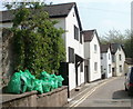
Green bags and white houses, Granville Street, Monmouth
Viewed from the edge of The Old Nags Head. http://www.geograph.org.uk/photo/1500834
Image: © Jaggery
Taken: 24 Apr 2011
0.02 miles
8
Old Dixton Road houses in Monmouth
Directly opposite the street named Burgage.
The rounded stonework on the right is in a corner of The Old Nags Head pub. http://www.geograph.org.uk/photo/4227966
Image: © Jaggery
Taken: 26 Oct 2014
0.02 miles
9
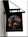
Rather a cute old nag, Monmouth
The sign hangs from a bracket on the wall of The Old Nags Head. http://www.geograph.org.uk/photo/4227966
Image: © Jaggery
Taken: 26 Oct 2014
0.02 miles
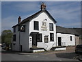
10
Old Nags Head, Monmouth
Pub on the corner of Old Dixton Road and Granville Street. http://www.geograph.org.uk/photo/4227975 to the name sign.
Cadw records that the early 19th century building incorporates in its structure remains of a tower of the eastern or Dixton Gate of the town. The medieval work is probably 15th century. How much fabric from this date survives in the present building is unknown. The Dixton Gate was otherwise demolished probably in the 18th century and was replaced by a turnpike gate further down the street. The Old Nags Head is Grade II (star) listed.
Image: © Jaggery
Taken: 10 Jun 2018
0.02 miles