IMAGES TAKEN NEAR TO
Upper Stanley Terrace, NEW TREDEGAR, NP24 6NL
Introduction
This page details the photographs taken nearby to Upper Stanley Terrace, NP24 6NL by members of the Geograph project.
The Geograph project started in 2005 with the aim of publishing, organising and preserving representative images for every square kilometre of Great Britain, Ireland and the Isle of Man.

There are currently over 7.5m images from over14,400 individuals and you can help contribute to the project by visiting https://www.geograph.org.uk
Image Map
Images are licensed for reuse under creativecommons.org/licenses/by-sa/2.0
Notes
- Clicking on the map will re-center to the selected point.
- The higher the marker number, the further away the image location is from the centre of the postcode.
Image Listing (115 Images Found)
Images are licensed for reuse under creativecommons.org/licenses/by-sa/2.0
Image
Details
Distance
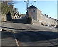
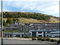
1
Bedwellty Road, New Tredegar
The road climbs to the SE away from New Tredegar. The sign on the right shows Markham 1¾ (miles).
Image: © Jaggery
Taken: 20 Jan 2011
0.01 miles
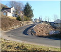
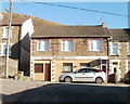
2
Junction of Bedwellty Road and Queen's Road, New Tredegar
Viewed from Bedwellty Road, which continues ahead on the left. On the right is Queen's Road. Just visible at centre left edge is the end of Gorse Terrace. http://www.geograph.org.uk/photo/2278398
Image: © Jaggery
Taken: 20 Jan 2011
0.01 miles
3
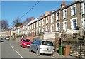
Queen's Road, New Tredegar
Houses on the east side of the road, viewed from near the corner of Lower Stanley Terrace.
Image: © Jaggery
Taken: 20 Jan 2011
0.01 miles
4
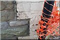
Ordnance Survey Cut Mark
This OS cut mark can be found on No1 Bedwellty Road. It marks a point 246.227m above mean sea level.
Image: © Adrian Dust
Taken: 12 Feb 2021
0.06 miles
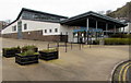
5
White Rose Primary School, Elliot's Town
Opened in 2004 to replace three ageing schools.
Image: © Robin Drayton
Taken: 10 Oct 2008
0.06 miles
6
New Tredegar Nomads Cycling Club
Club premises on Queen's Road, New Tredegar, opposite Upper Stanley Terrace.
Image: © Jaggery
Taken: 20 Jan 2011
0.06 miles
7
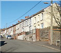
Gorse Terrace, New Tredegar
Houses on the east side of the street, bathed in bright January sunshine. Viewed from the Bedwellty Road end.
Image: © Jaggery
Taken: 20 Jan 2011
0.06 miles
8
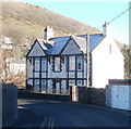
Elliot House, New Tredegar
Located on a bend in Bedwellty Road.
The name Elliot features in several locations in New Tredegar. Elliot's Colliery, (1888-1967) at its peak employed nearly 3,000 men. There is an Elliot Street nearby, and a district of the town is name Elliot's Town.
Image: © Jaggery
Taken: 20 Jan 2011
0.07 miles
9
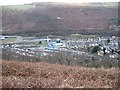
Elliot's Town from above
The buildings in the centre of the picture are the White Rose Primary School, library and community centre, with the colliery museum the grey-roofed building behind. They lie on either side of what used to be the main road up this side of the valley: the bypass was built further down, under the large white bridge seen end-on from this angle.
The same applies on the other side of the valley: the old main road is the uppermost horizontal line with the bypass below it (and the railway below that).
Image: © Colin Bell
Taken: 25 Dec 2008
0.08 miles
10
White Rose Primary School, New Tredegar
Located between White Rose Way (on this side) and School Street in the Elliot's Town area of New Tredegar.
Image: © Jaggery
Taken: 23 Jan 2016
0.08 miles