IMAGES TAKEN NEAR TO
Colliers Row, NEW TREDEGAR, NP24 6HD
Introduction
This page details the photographs taken nearby to Colliers Row, NP24 6HD by members of the Geograph project.
The Geograph project started in 2005 with the aim of publishing, organising and preserving representative images for every square kilometre of Great Britain, Ireland and the Isle of Man.

There are currently over 7.5m images from over14,400 individuals and you can help contribute to the project by visiting https://www.geograph.org.uk
Image Map
Images are licensed for reuse under creativecommons.org/licenses/by-sa/2.0
Notes
- Clicking on the map will re-center to the selected point.
- The higher the marker number, the further away the image location is from the centre of the postcode.
Image Listing (232 Images Found)
Images are licensed for reuse under creativecommons.org/licenses/by-sa/2.0
Image
Details
Distance
1
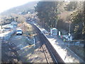
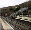
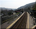
Tir-Phil railway station
Viewed from the A4049 road bridge. The station serves the small community of Tir-Phil and adjacent New Tredegar.
The single-track single-platform station is on the Rhymney Line, part of the Valley Lines network. Passenger trains are operated by Arriva Trains Wales. The next station is this direction is Brithdir. The next station in the opposite direction is Pontlottyn.
Image: © Jaggery
Taken: 20 Jan 2011
0.00 miles
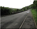
2
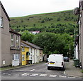
Hillside view from New Tredegar
From Commercial Street along George Street towards high ground in Tirphil.
Image: © Jaggery
Taken: 17 Jun 2019
0.03 miles
3
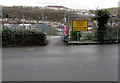
Temporary access to Tir-Phil railway station
Viewed across Station Row on January 28th 2016 during major construction work at the railway station.
Image: © Jaggery
Taken: 28 Jan 2016
0.03 miles
4
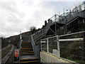
Steps up from platform 1 at Tir-Phil railway station
A long flight of steps ascends to Station Row where a notice http://www.geograph.org.uk/photo/4839447
states that this is a temporary station access. Viewed on January 28th 2016.
Image: © Jaggery
Taken: 28 Jan 2016
0.03 miles
5
Temporary access steps to and from platform 1, Tir-Phil railway station
Viewed on January 28th 2016 when the usual platform 1 entrance/exit is blocked during major construction work at the railway station. The long series of steps ascends to Station Row.
Image: © Jaggery
Taken: 28 Jan 2016
0.03 miles
6
Station Row, Tirphil
Looking to the southeast along the minor road towards Brithdir.
Image: © Jaggery
Taken: 5 Jun 2019
0.04 miles
7
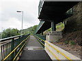
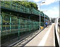
Zigzag ramp from platform 1 at Tir-Phil station
The ramp provides a step-free exit from the station.
Steep exit steps https://www.geograph.org.uk/photo/6187027 are behind the camera.
Image: © Jaggery
Taken: 17 Jun 2019
0.04 miles
8
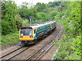
Railway line south of Tir-Phil
A pair of pacer units (Nos. 143624 and 142085) head away from Tir-Phil with a Rhymney to Barry Island working.
Image: © Gareth James
Taken: 26 May 2019
0.04 miles
9
Through Tir-Phil railway station
Viewed from the A4049 bridge. In April 2019, Tir-Phil is a two-platform station on the Rhymney Line between Pontlottyn station and Brithdir station (ahead). Station name signs show either Tir-Phil or Tir-phil whereas the village name is usually spelt Tirphil in English. The station formerly had only one platform as seen here https://www.geograph.org.uk/photo/2243473 in January 2011.
Image: © Jaggery
Taken: 15 Apr 2019
0.04 miles
10
Pedestrian access ramps at Tir-Phil railway station
Much altered since my last visit in 2007:
Image
Image: © Roger Cornfoot
Taken: 9 Aug 2022
0.05 miles