IMAGES TAKEN NEAR TO
Upper Road, NEW TREDEGAR, NP24 6EA
Introduction
This page details the photographs taken nearby to Upper Road, NP24 6EA by members of the Geograph project.
The Geograph project started in 2005 with the aim of publishing, organising and preserving representative images for every square kilometre of Great Britain, Ireland and the Isle of Man.

There are currently over 7.5m images from over14,400 individuals and you can help contribute to the project by visiting https://www.geograph.org.uk
Image Map
Images are licensed for reuse under creativecommons.org/licenses/by-sa/2.0
Notes
- Clicking on the map will re-center to the selected point.
- The higher the marker number, the further away the image location is from the centre of the postcode.
Image Listing (154 Images Found)
Images are licensed for reuse under creativecommons.org/licenses/by-sa/2.0
Image
Details
Distance
1
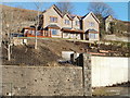
Hillside garden, Upper Road, Cwmsyfiog
There is little level land hereabouts, (the slope continues on the other side of the road) so the house garden is set out on the side of a steep hill.
Image: © Jaggery
Taken: 20 Jan 2011
0.04 miles
2
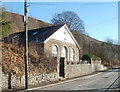
Former Libanus Chapel, Cwmsyfiog
Now a private residence, this is the former Libanus Chapel, Upper Road, Cwmsyfiog.
An inscription in an unpainted grey rectangle in the middle of the white paint shows the year 1896.
Image: © Jaggery
Taken: 20 Jan 2011
0.04 miles
3
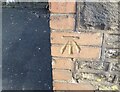
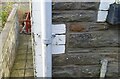
Ordnance Survey Cut Mark
This OS cut mark can be found on the old school wall. It marks a point 209.977m above mean sea level.
Image: © Adrian Dust
Taken: 12 Feb 2021
0.05 miles
4
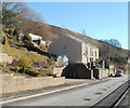
Cwmsyfiog house with a view across Brithdir
Recently-built house on an elevated site on the east side of Upper Road, Cwmsyfiog, facing the neighbouring village of Brithdir.
Image: © Jaggery
Taken: 20 Jan 2011
0.06 miles
5
Ordnance Survey Cut Mark
This OS cut mark can be found on No34 Upper Road. It marks a point 207.118m above mean sea level.
Image: © Adrian Dust
Taken: 12 Feb 2021
0.07 miles
6
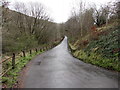
Road from Brithdir towards Cwmsyfiog
Descending into the valley of the Rhymney River.
Image: © Jaggery
Taken: 23 Jan 2016
0.09 miles

8
Southern boundary of Cwmsyfiog
The boundary sign is on Upper Road. Cwmsyfiog is on the SE side of New Tredegar.
Image: © Jaggery
Taken: 20 Jan 2011
0.11 miles
9
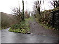
Track at the edge of Brithdir
On the south side of this http://www.geograph.org.uk/photo/4806298 road, near the railway bridge http://www.geograph.org.uk/photo/4806293 on the right.
Image: © Jaggery
Taken: 23 Jan 2016
0.11 miles
10
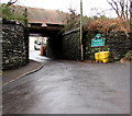
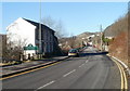
Brithdir - Please Drive Carefully
The village boundary sign is on the east side of a railway bridge, facing an unnamed side road from the A4049. Headroom shown on the triangular warning sign is 10' 6".
Image: © Jaggery
Taken: 23 Jan 2016
0.11 miles