1
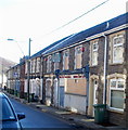
Side view of Cwmsyfiog Ex-Servicemen's Club and Institute
The club's name is on the side of the premises, but not on the front. http://www.geograph.org.uk/photo/2278481
Viewed across Queen's Road.
Image: © Jaggery
Taken: 20 Jan 2011
0.04 miles
2
The upper Rhymney Valley
Overlooking the valley communities of Cwmsyfiog, Elliot's Town, New Tredegar and Tirphil.
Centre left is the footbridge with reproduction of colliery winding gear http://www.geograph.org.uk/photo/504024 .
Image: © Robin Drayton
Taken: 27 Jun 2013
0.04 miles
3
Derelict Bonar Law Constitutional Workmen's Club, New Tredegar
Boarded-up and apparently long derelict, the former club is located among terraced houses, at 82-84 Queen's Road, New Tredegar
Image: © Jaggery
Taken: 20 Jan 2011
0.05 miles
4
A4049 from New Tredegar towards Cwmsyfiog
This part of the A4049 is on a bank of the Rhymney River.
Image: © Jaggery
Taken: 23 Jan 2016
0.06 miles
5
Ordnance Survey Cut Mark
This OS cut mark can be found on the Post Office, Tanlan Square. It marks a point 219.551m above mean sea level.
Image: © Adrian Dust
Taken: 12 Feb 2021
0.06 miles
6
White Rose Way, New Tredegar
Viewed from Cwmsyfiog, this is the A4049 which bypasses New Tredegar.
The colliery winding tower in the distance is a footbridge http://www.geograph.org.uk/photo/504024 .
Image: © Robin Drayton
Taken: 15 Dec 2010
0.06 miles
7
Cwmsyfiog Ex-Servicemen's Club and Institute
Located on the corner of Queen's Road and Elliot Street, New Tredegar. The club's name is shown on the side of the building http://www.geograph.org.uk/photo/2278487 facing the houses.
Image: © Jaggery
Taken: 20 Jan 2011
0.09 miles
8
Brithdir seen from above Elliot's Town
Looking south down the Rhymney valley. I wouldn't recommend, as we did, scrambling straight up this slope immediately after Christmas lunch!
Image: © Colin Bell
Taken: 25 Dec 2008
0.10 miles
9
View towards Elliot's Town from New Tredegar Business Park
Viewed across the Rhymney River flowing below the camera, out of shot in the foreground.
Image: © Jaggery
Taken: 23 Jan 2016
0.11 miles
10
Rhymney River, New Tredegar
Flowing below New Tredegar Business Park on the right.
Image: © Jaggery
Taken: 23 Jan 2016
0.11 miles


