IMAGES TAKEN NEAR TO
Aubry Terrace, EBBW VALE, NP23 7SN
Introduction
This page details the photographs taken nearby to Aubry Terrace, NP23 7SN by members of the Geograph project.
The Geograph project started in 2005 with the aim of publishing, organising and preserving representative images for every square kilometre of Great Britain, Ireland and the Isle of Man.

There are currently over 7.5m images from over14,400 individuals and you can help contribute to the project by visiting https://www.geograph.org.uk
Image Map
Images are licensed for reuse under creativecommons.org/licenses/by-sa/2.0
Notes
- Clicking on the map will re-center to the selected point.
- The higher the marker number, the further away the image location is from the centre of the postcode.
Image Listing (36 Images Found)
Images are licensed for reuse under creativecommons.org/licenses/by-sa/2.0
Image
Details
Distance
1
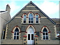
Tallistown Congregational Church, Cwm
Situated on Marine Street in this pit-village in the Ebbw valley.
Image: © Jonathan Billinger
Taken: 28 Jan 2010
0.04 miles
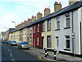
2
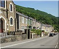
Station Terrace, Cwm
Houses on the east side of Station Terrace, viewed from opposite Tirzah Baptist Church.http://www.geograph.org.uk/photo/1931981
Image: © Jaggery
Taken: 23 Jun 2010
0.04 miles
3
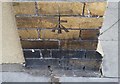
Ordnance Survey Cut Mark
This OS cut mark can be found on a building NE side of Marine Street. It marks a point 202.018m above mean sea level.
Image: © Adrian Dust
Taken: 4 Aug 2018
0.04 miles
4
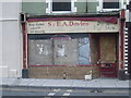
S & E.A. Davies Butchers in Cwm
Image: © Nick Mutton 01329 000000
Taken: 15 Dec 2007
0.04 miles
5
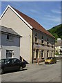
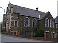
Salvation Army Cwm Corps
Salvation Army building on Aubrey Terrace, Cwm, viewed from the Marine Street side.
Image: © Jaggery
Taken: 23 Jun 2010
0.05 miles
6
Marine Street, Cwm
Looking north towards the Congregational Church, see Image
Image: © Jonathan Billinger
Taken: 28 Jan 2010
0.06 miles
7
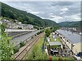
Road, rail and housing in Cwm
Typical Welsh valleys community - below Ebbw Vale.
Image: © Alan Hughes
Taken: 13 Aug 2024
0.08 miles
8
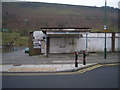
Disused petrol station in Cwm
Image: © Nick Mutton 01329 000000
Taken: 15 Dec 2007
0.08 miles
10

Tallistown view
Looking north-east, at right angles to the main road, this shows the proximity of the steep valley side to this pit village.
The houses are the backs of King Street. Traffic on the elevated A4046 can be seen level with the roof apex.
Image: © Jonathan Billinger
Taken: 28 Jan 2010
0.09 miles