IMAGES TAKEN NEAR TO
Market Square, EBBW VALE, NP23 6YN
Introduction
This page details the photographs taken nearby to Market Square, NP23 6YN by members of the Geograph project.
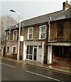
The Geograph project started in 2005 with the aim of publishing, organising and preserving representative images for every square kilometre of Great Britain, Ireland and the Isle of Man.

There are currently over 7.5m images from over14,400 individuals and you can help contribute to the project by visiting https://www.geograph.org.uk
Image Map
Images are licensed for reuse under creativecommons.org/licenses/by-sa/2.0
Notes
- Clicking on the map will re-center to the selected point.
- The higher the marker number, the further away the image location is from the centre of the postcode.
Image Listing (162 Images Found)
Images are licensed for reuse under creativecommons.org/licenses/by-sa/2.0
Image
Details
Distance
1
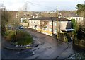
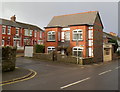
Station Cottages, Ebbw Vale
Two semi-detached houses in Station Approach, viewed from a footbridge. http://www.geograph.org.uk/photo/2733450
The name of the cottages and street is a relic of a long-closed railway station. Ebbw Vale's only one currently (December 2011) is Ebbw Vale Parkway, http://www.geograph.org.uk/photo/2624631 about two miles to the south.
Image: © Jaggery
Taken: 17 Dec 2011
0.02 miles
2
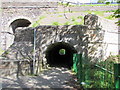
Light at the end of the tunnel, Ebbw Vale
Viewed from The Crescent. The pedestrian tunnel is on the east side of Grade II listed Newtown Bridge. http://www.geograph.org.uk/photo/617492
Image: © Jaggery
Taken: 27 May 2015
0.02 miles
3
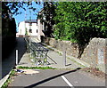
Path from The Crescent to Libanus Road, Ebbw Vale
Maps name this short pedestrianised street Station Road, a relic
of a long since demolished railway station behind the camera.
At the late May 2015 date of this photo, Ebbw Vale has two railway
stations, Ebbw Vale Parkway and Ebbw Vale Town, both to the south.
Image: © Jaggery
Taken: 27 May 2015
0.03 miles
4
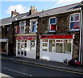
Two Libanus Road takeaways, Ebbw Vale
Maya Bangladeshi & Indian takeaway on the right, Wok U Like Chinese takeaway on the left.
Image: © Jaggery
Taken: 27 May 2015
0.04 miles
5
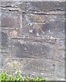
Ordnance Survey Cut Mark
This OS cut mark can be found on the wall west side of Libanus Street. It marks a point 296.016m above mean sea level.
Image: © Adrian Dust
Taken: 18 Aug 2018
0.04 miles
6
Footbridge across Steel Works Road, Ebbw Vale
The footbridge is about 60 metres north of Grade II listed Newtown Bridge. http://www.geograph.org.uk/photo/2733443
Image: © Jaggery
Taken: 17 Dec 2011
0.04 miles
7
Treve Cottage, Ebbw Vale
Located between Libanus Road, Beulah Place, and Aynho Place. http://www.geograph.org.uk/photo/2733536
Image: © Jaggery
Taken: 17 Dec 2011
0.04 miles
8
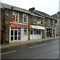
Two Libanus Road takeaways, Ebbw Vale
Side-by-side on Libanus Road are Wok U Like, Chinese takeaway, and Ebbw Vale Tandoori, Indian takeaway.
Image: © Jaggery
Taken: 17 Dec 2011
0.04 miles
9
Deano's Luxury Coffee & Sandwich Bar, Ebbw Vale
Located on Libanus Road near the Beulah Place junction.
Image: © Jaggery
Taken: 17 Dec 2011
0.04 miles
10
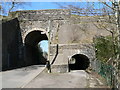
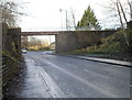
Western Bridge, The Crescent, Ebbw Vale
This is the western bridge of the Newtown Bridge complex and carries The Crescent under the former railway. Originally constructed of wood this was rebuilt in stone in 1859. This structure collapsed killing two men and was rebuilt in 1861. This is the road bridge we see today. Next door a prefabricated concrete pedestrian tunnel was put in 1964. The whole Newtown Bridge is a Grade II listed structure.
Image: © Colin Cheesman
Taken: 3 Apr 2008
0.04 miles