1
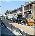
Church Street, Ebbw Vale
The east side of the street, viewed from opposite Canolfan Canu. http://www.geograph.org.uk/photo/2625560
Image: © Jaggery
Taken: 29 Sep 2011
0.04 miles
2
Alexandra Street, Ebbw Vale
Looking south from the corner of a car park; Christ Church is in the background.
Image: © M J Roscoe
Taken: 11 Jan 2018
0.04 miles
3
Canolfan Canu, Ebbw Vale
Formerly Bethesda Methodist Chapel built in 1878, the building is now named Canolfan Canu, Welsh for Singing Centre. It has been the headquarters of Ebbw Vale Male Choir since about 1970.
Image: © Jaggery
Taken: 29 Sep 2011
0.08 miles
4
Cyfleusterau cyhoeddus wedi eu haddasu / Converted public conveniences
This building is now an architect's studio, but the separate entrances at each end and the inscription EVUDC suggest a different former use.
Image: © Ceri Thomas
Taken: 5 Aug 2010
0.08 miles
5
Eglwys Crist / Christ Church
Christ Church dominates its surroundings. The pink structure in the background is the Eisteddfod pavilion.
Image: © Ceri Thomas
Taken: 5 Aug 2010
0.08 miles
6
Ebbw Vale Delivery Office
Royal Mail premises on the west side of the A4046.
There is no vehicular access from Holland Street on the far side.
Image: © Jaggery
Taken: 16 May 2014
0.09 miles
7
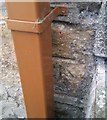
Ordnance Survey Cut Mark
This OS cut mark can be found on No1 Fern Cottage, Mount Street. It marks a point 327.441m above mean sea level.
Image: © Adrian Dust
Taken: 18 Aug 2018
0.09 miles
8
Greening of waste land formerly part of Ebbw Vale steelworks
The large site formerly occupied by Ebbw Vale steelworks has been (and is being) adapted for various uses. Ahead, looking towards the A4046, the land is slowly changing to green. The recently built sports centre http://www.geograph.org.uk/photo/4479197
is behind the camera. A college campus is nearby. Today, Sunday May 17th 2015, sees the opening of a c3km railway extension through the former steelworks site to a new terminus at Ebbw Vale Town station.
Image: © Jaggery
Taken: 17 May 2015
0.09 miles
9
3-storey building alongside the A4046, Ebbw Vale
As well as boards advertising nearby businesses, there was a For Sale board on this building near Holland Street on the west side of the A4046 in mid-May 2014.
Image: © Jaggery
Taken: 16 May 2014
0.10 miles
10
Christchurch Ebbw Vale
Steeple shrouded in scaffolding and covered in a dusting of snow, Christchurch sits waiting to emerge like a butterfly. This picture was taken not long after the steeple was nearly destroyed by fire just before Christmas 2003
Image: © Julian Brading
Taken: 11 Mar 2004
0.10 miles


