IMAGES TAKEN NEAR TO
Holland Street, EBBW VALE, NP23 6HY
Introduction
This page details the photographs taken nearby to Holland Street, NP23 6HY by members of the Geograph project.
The Geograph project started in 2005 with the aim of publishing, organising and preserving representative images for every square kilometre of Great Britain, Ireland and the Isle of Man.

There are currently over 7.5m images from over14,400 individuals and you can help contribute to the project by visiting https://www.geograph.org.uk
Image Map
Images are licensed for reuse under creativecommons.org/licenses/by-sa/2.0
Notes
- Clicking on the map will re-center to the selected point.
- The higher the marker number, the further away the image location is from the centre of the postcode.
Image Listing (112 Images Found)
Images are licensed for reuse under creativecommons.org/licenses/by-sa/2.0
Image
Details
Distance
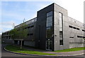
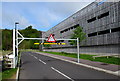
1
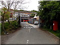
Ebbw Vale Delivery Office
Royal Mail premises on the west side of the A4046.
There is no vehicular access from Holland Street on the far side.
Image: © Jaggery
Taken: 16 May 2014
0.02 miles
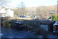
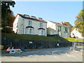
2
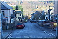
Cross roads, Alexandra Street, Ebbw Vale
Unnamed minor road crossing the end of Alexandra Street Image, right foreground, and running downhill to cross Holland Street to become a cul-de-sac, centre.
Image: © M J Roscoe
Taken: 11 Jan 2018
0.03 miles
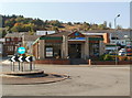
3
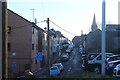
Alexandra Street, Ebbw Vale
Looking south from the corner of a car park; Christ Church is in the background.
Image: © M J Roscoe
Taken: 11 Jan 2018
0.05 miles
4
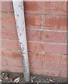
Ordnance Survey Cut Mark
This OS cut mark can be found on the old PC, west side of Armoury Terrace. It marks a point 305.565m above mean sea level.
Image: © Adrian Dust
Taken: 18 Aug 2018
0.07 miles
5
Towards The Walk, Ebbw Vale
Looking across Holland Street towards McDonald's on the southern side of The Walk; viewed from the north east corner of the car park on Armoury Terrace. The white building, left, is on The Walk, and the former industrial land behind seems to be in need of regeneration in this once thriving steel town.
Image: © M J Roscoe
Taken: 11 Jan 2018
0.08 miles
6
West side of a Lime Avenue multi-storey car park, Ebbw Vale
The parking levels here include the rooftop.
Image: © Jaggery
Taken: 17 May 2015
0.08 miles
7
Height restriction at the Lime Avenue entrance to a multi-storey car park, Ebbw Vale
A metal barrier enforces a maximum vehicle height of 2.1 metres (6' 11").
Image: © Jaggery
Taken: 17 May 2015
0.09 miles
8
Former Pets Ahead premises, Ebbw Vale
A chartered surveyors' notice in the window of Unit 9, The Walk Retail Centre shows RETAIL UNIT TO LET.
Image: © Jaggery
Taken: 29 Sep 2011
0.10 miles
9
Southern end of Eureka Place, Ebbw Vale
The houses are set several metres above road level. The B4478 Church Street becomes the B4478 Eureka Place ahead.
Image: © Jaggery
Taken: 29 Sep 2011
0.10 miles
10
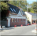
Armoury Studios Ebbw Vale
Architects' premises at 19 Armoury Terrace. This is a converted public convenience. Below the conspicuous 1932 on the wall, whitewashed letters spell out EVUDC, (Ebbw Vale Urban District Council). When the council was abolished in 1974, following local government reorganisation, its functions passed to the new Borough of Blaenau Gwent, now (2011) known as Blaenau Gwent County Borough Council.
Image: © Jaggery
Taken: 29 Sep 2011
0.10 miles