IMAGES TAKEN NEAR TO
Queen Square, EBBW VALE, NP23 6EF
Introduction
This page details the photographs taken nearby to Queen Square, NP23 6EF by members of the Geograph project.
The Geograph project started in 2005 with the aim of publishing, organising and preserving representative images for every square kilometre of Great Britain, Ireland and the Isle of Man.

There are currently over 7.5m images from over14,400 individuals and you can help contribute to the project by visiting https://www.geograph.org.uk
Image Map
Images are licensed for reuse under creativecommons.org/licenses/by-sa/2.0
Notes
- Clicking on the map will re-center to the selected point.
- The higher the marker number, the further away the image location is from the centre of the postcode.
Image Listing (165 Images Found)
Images are licensed for reuse under creativecommons.org/licenses/by-sa/2.0
Image
Details
Distance
1
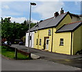
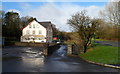
Y Bwthyn Melyn possibly the oldest house in Ebbw Vale
The year 1695 is on the nameplate of Y Bwthyn Melyn (Welsh for The Yellow Cottage).
A passer-by said he thought this is the oldest house in Ebbw Vale.
Image: © Jaggery
Taken: 27 May 2015
0.02 miles
2
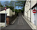
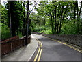
No entry to a straight part of The Crescent, Ebbw Vale
The Crescent ascends towards Queen Square and the A4046.
Image: © Jaggery
Taken: 27 May 2015
0.02 miles
3
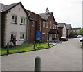
The Rookery Care Centre in Ebbw Vale
Owned by Four Seasons Health Care, The Rookery has accommodation for 41 residents.
Image: © Jaggery
Taken: 27 May 2015
0.03 miles
4
Descent from Queen Square towards The Crescent, Ebbw Vale
A sign http://www.geograph.org.uk/photo/4496162 in Queen Square shows that this road is unsuitable for heavy goods vehicles.
Double yellow lines on both sides of the road make parking illegal at any time.
Image: © Jaggery
Taken: 27 May 2015
0.05 miles
5
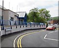
Queen Square, Ebbw Vale
Queen Square (Sgwâr y Frenhines in Welsh) connects the A4046 with The Crescent ahead.
This route is not suitable for HGVs. http://www.geograph.org.uk/photo/4496162
Image: © Jaggery
Taken: 27 May 2015
0.07 miles
6
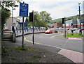
Queen Square unsuitable for heavy goods vehicles, Ebbw Vale
Queen Square diverges from the A4046. Ahead is a steep narrow descent.
Image: © Jaggery
Taken: 27 May 2015
0.07 miles
7
The Croft, Steel Works Road, Ebbw Vale
The Croft, near the northern end of Steel Works Road, contains ten flats.
Image: © Jaggery
Taken: 17 Dec 2011
0.08 miles
8
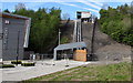
Ebbw Vale Mechanical Link
Viewed from Lime Avenue. Not yet open in mid May 2015, the £2.5 million Mechanical Link is part of the Ebbw Vale Town Regeneration Programme. It is a cableway system between the former steelworks site (now occupied by a college campus, a school and the newly-opened Ebbw Vale Town railway station) up to the edge of the A4046.
A cabin holding about 20 people (weight limit 1,850 kg) will provide an easy and efficient pedestrian link to and from the town centre. The track is c47m long and rises c23m. Each journey will take about three minutes.
Image: © Jaggery
Taken: 17 May 2015
0.08 miles
9

Side view of the Ebbw Vale Mechanical Link
Viewed from Lime Avenue. Not yet open in mid May 2015, the £2.5 million Mechanical Link is part of the Ebbw Vale Town Regeneration Programme. It is a cableway system between the former steelworks site (now occupied by a college campus, a school and the newly-opened Ebbw Vale Town railway station) up to the edge of the A4046.
A cabin holding about 20 people (weight limit 1,850 kg) will provide an easy and efficient pedestrian link to and from the town centre. The track is c47m long and rises c23m. Each journey will take about three minutes.
Image: © Jaggery
Taken: 17 May 2015
0.08 miles