IMAGES TAKEN NEAR TO
Mount Street, EBBW VALE, NP23 6DP
Introduction
This page details the photographs taken nearby to Mount Street, NP23 6DP by members of the Geograph project.
The Geograph project started in 2005 with the aim of publishing, organising and preserving representative images for every square kilometre of Great Britain, Ireland and the Isle of Man.

There are currently over 7.5m images from over14,400 individuals and you can help contribute to the project by visiting https://www.geograph.org.uk
Image Map
Images are licensed for reuse under creativecommons.org/licenses/by-sa/2.0
Notes
- Clicking on the map will re-center to the selected point.
- The higher the marker number, the further away the image location is from the centre of the postcode.
Image Listing (43 Images Found)
Images are licensed for reuse under creativecommons.org/licenses/by-sa/2.0
Image
Details
Distance
1
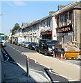
Church Street, Ebbw Vale
The east side of the street, viewed from opposite Canolfan Canu. http://www.geograph.org.uk/photo/2625560
Image: © Jaggery
Taken: 29 Sep 2011
0.02 miles
2
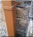
Ordnance Survey Cut Mark
This OS cut mark can be found on No1 Fern Cottage, Mount Street. It marks a point 327.441m above mean sea level.
Image: © Adrian Dust
Taken: 18 Aug 2018
0.03 miles
3
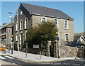
Cyfleusterau cyhoeddus wedi eu haddasu / Converted public conveniences
This building is now an architect's studio, but the separate entrances at each end and the inscription EVUDC suggest a different former use.
Image: © Ceri Thomas
Taken: 5 Aug 2010
0.04 miles
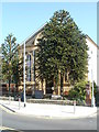
4
Canolfan Canu, Ebbw Vale
Formerly Bethesda Methodist Chapel built in 1878, the building is now named Canolfan Canu, Welsh for Singing Centre. It has been the headquarters of Ebbw Vale Male Choir since about 1970.
Image: © Jaggery
Taken: 29 Sep 2011
0.05 miles
5
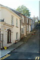
Mount Street, Ebbw Vale
Houses on the south side of Mount Street, a steep side street viewed from Church Street.
Image: © Jaggery
Taken: 29 Sep 2011
0.06 miles
6
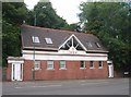
1st Ebbw Vale (Penuel) Scout Group HQ, Ebbw Vale
Formed in 1910, the 1st Ebbw Vale Scout Group had its headquarters in various locations in Ebbw Vale, before buying and converting this building, the former Penuel chapel located on the corner of Church Street and Mount Street. When the building was officially opened as their new HQ in late 1989, the group added (Penuel) to its name.
Image: © Jaggery
Taken: 29 Sep 2011
0.06 miles
7
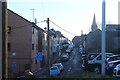
Alexandra Street, Ebbw Vale
Looking south from the corner of a car park; Christ Church is in the background.
Image: © M J Roscoe
Taken: 11 Jan 2018
0.08 miles
8
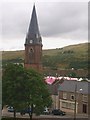
Eglwys Crist / Christ Church
Christ Church dominates its surroundings. The pink structure in the background is the Eisteddfod pavilion.
Image: © Ceri Thomas
Taken: 5 Aug 2010
0.08 miles
9
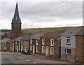
Eglwys Crist a thai teras / Christ church and terraced housing
Image: © Ceri Thomas
Taken: 5 Aug 2010
0.09 miles
10
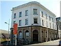
Former Armoury Hill bank building converted to flats, Ebbw Vale
Though the lettering has been removed, the outline of BARCLAYS BANK LIMITED remains on the building, Armoury Court, Armoury Hill, now converted to flats.
Image: © Jaggery
Taken: 29 Sep 2011
0.09 miles