1
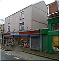
Former Pets Ahead premises, Ebbw Vale
A chartered surveyors' notice in the window of Unit 9, The Walk Retail Centre shows RETAIL UNIT TO LET.
Image: © Jaggery
Taken: 29 Sep 2011
0.03 miles
2
Ordnance Survey Cut Mark
This OS cut mark can be found on the old PC, west side of Armoury Terrace. It marks a point 305.565m above mean sea level.
Image: © Adrian Dust
Taken: 18 Aug 2018
0.04 miles
3
Towards The Walk, Ebbw Vale
Looking across Holland Street towards McDonald's on the southern side of The Walk; viewed from the north east corner of the car park on Armoury Terrace. The white building, left, is on The Walk, and the former industrial land behind seems to be in need of regeneration in this once thriving steel town.
Image: © M J Roscoe
Taken: 11 Jan 2018
0.04 miles
4
Covered walkway, Bethcar Street, Ebbw Vale
Viewed from Armoury Terrace. A long sloping roof projects from shops on the east side of the street.
Image: © Jaggery
Taken: 29 Sep 2011
0.06 miles
5
Market Tavern, Ebbw Vale
Pub on the corner of Bethcar Street and The Walk. A notice on the wall states that there is live music every Friday and Saturday, with free admission.
Image: © Jaggery
Taken: 29 Sep 2011
0.06 miles
6
The Plug, Ebbw Vale
Electrical and fancy goods shop, 77 Bethcar Street.
Image: © Jaggery
Taken: 17 Dec 2011
0.06 miles
7
Cross roads, Alexandra Street, Ebbw Vale
Unnamed minor road crossing the end of Alexandra Street
Image, right foreground, and running downhill to cross Holland Street to become a cul-de-sac, centre.
Image: © M J Roscoe
Taken: 11 Jan 2018
0.07 miles
8
Ebbw Vale Delivery Office
Royal Mail premises on the west side of the A4046.
There is no vehicular access from Holland Street on the far side.
Image: © Jaggery
Taken: 16 May 2014
0.09 miles
9
Southern end of Eureka Place, Ebbw Vale
The houses are set several metres above road level. The B4478 Church Street becomes the B4478 Eureka Place ahead.
Image: © Jaggery
Taken: 29 Sep 2011
0.10 miles
10
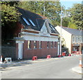
Armoury Studios Ebbw Vale
Architects' premises at 19 Armoury Terrace. This is a converted public convenience. Below the conspicuous 1932 on the wall, whitewashed letters spell out EVUDC, (Ebbw Vale Urban District Council). When the council was abolished in 1974, following local government reorganisation, its functions passed to the new Borough of Blaenau Gwent, now (2011) known as Blaenau Gwent County Borough Council.
Image: © Jaggery
Taken: 29 Sep 2011
0.10 miles


