IMAGES TAKEN NEAR TO
Highlands Crescent, EBBW VALE, NP23 5RQ
Introduction
This page details the photographs taken nearby to Highlands Crescent, NP23 5RQ by members of the Geograph project.
The Geograph project started in 2005 with the aim of publishing, organising and preserving representative images for every square kilometre of Great Britain, Ireland and the Isle of Man.

There are currently over 7.5m images from over14,400 individuals and you can help contribute to the project by visiting https://www.geograph.org.uk
Image Map
Images are licensed for reuse under creativecommons.org/licenses/by-sa/2.0
Notes
- Clicking on the map will re-center to the selected point.
- The higher the marker number, the further away the image location is from the centre of the postcode.
Image Listing (42 Images Found)
Images are licensed for reuse under creativecommons.org/licenses/by-sa/2.0
Image
Details
Distance
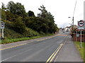
1
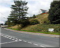
Junction in Beaufort
Left along the A4047 for Beaufort (½ mile).
Right along the A4047 for Beaufort Hill (¼ mile) and Brynmawr (1½ miles).
Image: © Jaggery
Taken: 10 Sep 2013
0.05 miles
2
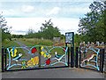
Colourful entrance to a nature reserve
Image: © Robin Drayton
Taken: 30 Jul 2013
0.05 miles
3
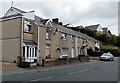
Vale View, Beaufort
Vale View is a row of 4 houses on the north side of the A4047.
Image: © Jaggery
Taken: 10 Sep 2013
0.06 miles
4
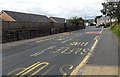
Road markings on the A4047 in Beaufort
Bilingualism means that bus stop road markings in Wales use up about twice the space (and paint) needed for bus stops in England. The Welsh for BUS STOP is SAFLE BWS. The same applies to the white on red SLOW ARAF sign on the road surface in the background.
Image: © Jaggery
Taken: 10 Sep 2013
0.06 miles
5
Weight restriction on the A4047 towards Beaufort Hill
I've seen many similar signs but have never seen a weighbridge in the vicinity, so I wonder how this restriction is enforced. Experts will know when a vehicle is much heavier than 7.5 tonnes, but what about a vehicle that weighs 7.4 tonnes unladen and 7.6 tonnes when fully loaded...
Image: © Jaggery
Taken: 10 Sep 2013
0.08 miles
6
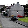
Five houses in Five Houses, Beaufort
The five houses in a row are 1-5 Five Houses. Just as well a sixth house was never added...
Image: © Jaggery
Taken: 10 Sep 2013
0.09 miles
7
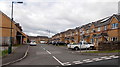
Heol Siloam, Beaufort
Heol Siloam is a 120 metre long cul-de-sac of modern houses.
The street name suggests that this used to be the location of a chapel or church named Siloam.
Image: © Jaggery
Taken: 10 Sep 2013
0.09 miles
8
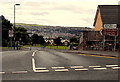
Road from Beaufort to Ebbw Vale
An unnamed road heads south away from the A4047.
The sign on the right shows 1¼ (miles) to Ebbw Vale.
Image: © Jaggery
Taken: 10 Sep 2013
0.10 miles
9
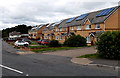
Nine solar panels, Frost Road, Beaufort
The panels face SSW, almost the optimal orientation of south.
Image: © Jaggery
Taken: 10 Sep 2013
0.12 miles
10
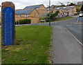
Vertical boundary sign, Beaufort
The road from Ebbw Vale reaches the southern edge of Beaufort, a village in the county borough of Blaenau Gwent. The left turn is into Frost Road.
Image: © Jaggery
Taken: 10 Sep 2013
0.12 miles