1
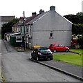
Bangor Road bungalows, Beaufort
The bungalows are opposite hilltop trees on the south side of the road.
Image: © Jaggery
Taken: 10 Sep 2013
0.04 miles
2
Weight restriction on the A4047 towards Beaufort Hill
I've seen many similar signs but have never seen a weighbridge in the vicinity, so I wonder how this restriction is enforced. Experts will know when a vehicle is much heavier than 7.5 tonnes, but what about a vehicle that weighs 7.4 tonnes unladen and 7.6 tonnes when fully loaded...
Image: © Jaggery
Taken: 10 Sep 2013
0.04 miles
3
Five houses in Five Houses, Beaufort
The five houses in a row are 1-5 Five Houses. Just as well a sixth house was never added...
Image: © Jaggery
Taken: 10 Sep 2013
0.05 miles
4
Ordnance Survey Cut Mark
This OS cut mark can be found on No59 Beaufort Hill. It marks a point 382.153m above mean sea level.
Image: © Adrian Dust
Taken: 4 Oct 2018
0.10 miles
5
Junction in Beaufort
Left along the A4047 for Beaufort (½ mile).
Right along the A4047 for Beaufort Hill (¼ mile) and Brynmawr (1½ miles).
Image: © Jaggery
Taken: 10 Sep 2013
0.10 miles
6
Road from Beaufort to Ebbw Vale
An unnamed road heads south away from the A4047.
The sign on the right shows 1¼ (miles) to Ebbw Vale.
Image: © Jaggery
Taken: 10 Sep 2013
0.11 miles
7
Vertical boundary sign, Beaufort
The road from Ebbw Vale reaches the southern edge of Beaufort, a village in the county borough of Blaenau Gwent. The left turn is into Frost Road.
Image: © Jaggery
Taken: 10 Sep 2013
0.11 miles
8
Boundary monolith, Beaufort
Locaed near Frost Road. The Beaufort boundary sign http://www.geograph.org.uk/photo/3935321 is on the other side of the rock.
Image: © Jaggery
Taken: 10 Sep 2013
0.12 miles
9
Road markings on the A4047 in Beaufort
Bilingualism means that bus stop road markings in Wales use up about twice the space (and paint) needed for bus stops in England. The Welsh for BUS STOP is SAFLE BWS. The same applies to the white on red SLOW ARAF sign on the road surface in the background.
Image: © Jaggery
Taken: 10 Sep 2013
0.14 miles
10
Vale View, Beaufort
Vale View is a row of 4 houses on the north side of the A4047.
Image: © Jaggery
Taken: 10 Sep 2013
0.15 miles


