IMAGES TAKEN NEAR TO
Church Avenue, EBBW VALE, NP23 5RD
Introduction
This page details the photographs taken nearby to Church Avenue, NP23 5RD by members of the Geograph project.
The Geograph project started in 2005 with the aim of publishing, organising and preserving representative images for every square kilometre of Great Britain, Ireland and the Isle of Man.

There are currently over 7.5m images from over14,400 individuals and you can help contribute to the project by visiting https://www.geograph.org.uk
Image Map
Images are licensed for reuse under creativecommons.org/licenses/by-sa/2.0
Notes
- Clicking on the map will re-center to the selected point.
- The higher the marker number, the further away the image location is from the centre of the postcode.
Image Listing (40 Images Found)
Images are licensed for reuse under creativecommons.org/licenses/by-sa/2.0
Image
Details
Distance
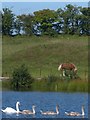
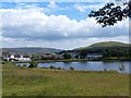
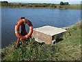
2
Lower Boat Pond
The southern edge taken from the car park.
Image: © Robin Drayton
Taken: 5 Sep 2013
0.03 miles
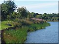
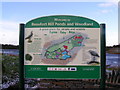
3

Lower Boat Pond, Beaufort
This is the larger of the two Boat Ponds that form part of what is now Beaufort Hill Ponds and Woodlands, run by a volunteer group on land owned by Blaenau Gwent County Borough Council. The ponds were originally created in 1780 to supply the Nantyglo Iron Works and later the Ebbw Vale Steelworks till that closed in 2002. They are now a haven for wildlife, popular with locals for walking and dog walking and are fished.
Image: © Colin Cheesman
Taken: 20 Jan 2019
0.05 miles
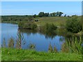
5
Lower Boat Pond, Beaufort
Viewed from Upper Boat Pond.
Image: © Robin Drayton
Taken: 30 Jul 2013
0.06 miles
6
The eastern end of Lower Boat Pond
The view from the small car park in Little Lane.
Image: © Robin Drayton
Taken: 5 Sep 2013
0.06 miles
7
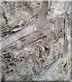
Ordnance Survey Cut Mark
This OS cut mark can be found on No103 Beaufort Hill. It marks a point 388.227m above mean sea level.
Image: © Adrian Dust
Taken: 4 Oct 2018
0.06 miles
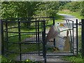
9
Beaufort Hill Woodland, Southern Reservoir
Image: © Kev Griffin
Taken: 4 Oct 2007
0.07 miles