IMAGES TAKEN NEAR TO
South Bank, EBBW VALE, NP23 5QU
Introduction
This page details the photographs taken nearby to South Bank, NP23 5QU by members of the Geograph project.
The Geograph project started in 2005 with the aim of publishing, organising and preserving representative images for every square kilometre of Great Britain, Ireland and the Isle of Man.

There are currently over 7.5m images from over14,400 individuals and you can help contribute to the project by visiting https://www.geograph.org.uk
Image Map
Images are licensed for reuse under creativecommons.org/licenses/by-sa/2.0
Notes
- Clicking on the map will re-center to the selected point.
- The higher the marker number, the further away the image location is from the centre of the postcode.
Image Listing (40 Images Found)
Images are licensed for reuse under creativecommons.org/licenses/by-sa/2.0
Image
Details
Distance
1
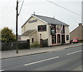
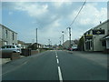
Farmers Arms, Beaufort Hill
Pub on the south side of Beaufort Hill (A4047) between Big Lane and Little Lane.
Image: © Jaggery
Taken: 28 Apr 2010
0.05 miles
2
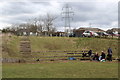
Amphitheatre classroom, Parc Nant-y-Waun, Beaufort
A Gwent Wildlife Trust working party enjoying a lunch break in the outdoor theatre, Image, near an entrance to the park.
Image: © M J Roscoe
Taken: 12 Apr 2016
0.06 miles
3
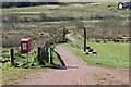
Gravel path, Parc Nant-y-Waun, Beaufort
The path runs down the side of the outdoor classroom Image through tree plantations towards marshy areas of this local nature reserve and to the Ebbw Fach Trail.
Image: © M J Roscoe
Taken: 12 Apr 2016
0.09 miles
4
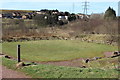
Outdoor classroom, Parc Nant-y-Waun, Beaufort
This amphitheatre, seen from above, was completed in 2008. The park, established in 2007, is on landscaped old mineral workings and reservoirs, http://parcnantywaun.org.uk.
Image: © M J Roscoe
Taken: 12 Apr 2016
0.09 miles
6
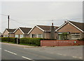
Bungalows, Beaufort
Bungalows on the north side of the A4047, near the corner of Big Lane. http://www.geograph.org.uk/photo/1829975
Image: © Jaggery
Taken: 28 Apr 2010
0.10 miles
7
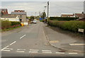
Big Lane, Beaufort
Big Lane heads away from Beaufort Hill towards Farmers Lane.
Image: © Jaggery
Taken: 28 Apr 2010
0.10 miles
8
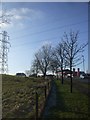
Power transmission line, ice-tipped branches, and filling station, Brynmawr
Image: © John Lord
Taken: 11 Feb 2012
0.12 miles
9
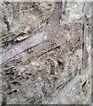
Ordnance Survey Cut Mark
This OS cut mark can be found on No103 Beaufort Hill. It marks a point 388.227m above mean sea level.
Image: © Adrian Dust
Taken: 4 Oct 2018
0.12 miles
10
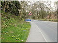
The western edge of Brynmawr
The A4047 heads away from Beaufort towards the Brynmawr boundary.
Brynmawr, at an average elevation of 1,200 feet (about 365 metres) above sea level is the highest town in South Wales. It is twinned with Camors (Brittany, France).
Image: © Jaggery
Taken: 28 Apr 2010
0.14 miles