IMAGES TAKEN NEAR TO
Bryn Awelon Road, EBBW VALE, NP23 5ND
Introduction
This page details the photographs taken nearby to Bryn Awelon Road, NP23 5ND by members of the Geograph project.
The Geograph project started in 2005 with the aim of publishing, organising and preserving representative images for every square kilometre of Great Britain, Ireland and the Isle of Man.

There are currently over 7.5m images from over14,400 individuals and you can help contribute to the project by visiting https://www.geograph.org.uk
Image Map
Images are licensed for reuse under creativecommons.org/licenses/by-sa/2.0
Notes
- Clicking on the map will re-center to the selected point.
- The higher the marker number, the further away the image location is from the centre of the postcode.
Image Listing (42 Images Found)
Images are licensed for reuse under creativecommons.org/licenses/by-sa/2.0
Image
Details
Distance
1
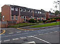
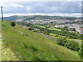
Bryn Awelon houses near Beaufort
Viewed from the corner of Ty'r Meddyg http://www.geograph.org.uk/photo/3977611 looking across the Beaufort to Ebbw Vale road.
Image: © Jaggery
Taken: 10 Sep 2013
0.02 miles
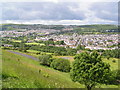
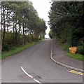
3
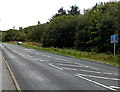
North to Beaufort
The road from Ebbw Vale to Beaufort passes broken white lines at the edge of Bryn Awelon Road. http://www.geograph.org.uk/photo/3977662
Image: © Jaggery
Taken: 10 Sep 2013
0.03 miles
4
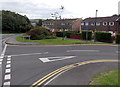
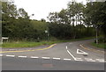
Junction, Bryn Awelon Road near Beaufort
Viewed from the corner of the road descending from Beaufort to Ebbw Vale. The street name sign shows Bryn Awelon Road whereas various maps show only Bryn Awelon. A dark blue sign shows Unsuitable for heavy goods vehicles.
Image: © Jaggery
Taken: 10 Sep 2013
0.04 miles
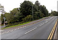
5
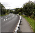
Roadside barrier on a bend in the road from Beaufort to Ebbw Vale
The road descends from Beaufort towards Ebbw Vale.
Image: © Jaggery
Taken: 10 Sep 2013
0.04 miles
7
Police vehicles only near Beaufort
Showing Police vehicles only, the blue sign is alongside the road ascending from Ebbw Vale to Beaufort.
Image: © Jaggery
Taken: 10 Sep 2013
0.07 miles
8
Ty'r Meddyg, Ebbw Vale
The name sign on the left shows Ty'r Meddyg (Welsh for The Doctor's House),
a lane (not a through route) heading SE away from the Ebbw Vale to Beaufort road.
Image: © Jaggery
Taken: 10 Sep 2013
0.08 miles
9
Yellow grit bin at the edge of Ty'r Meddyg near Beaufort
The contents of the bin are spread on the road during periods of icy or snowy weather. At an elevation here of about 320 metres (c1,050 ft) above mean sea level, the winter climate is significantly harsher than in locations near sea level in South Wales, so this grit bin will most likely be used several times in an average winter when the contents of similar bins elsewhere are not needed.
Image: © Jaggery
Taken: 10 Sep 2013
0.08 miles
10
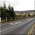
Slow down on the approach to Ebbw Vale
Markings painted on the road descending from Beaufort to Ebbw Vale.
Image: © Jaggery
Taken: 10 Sep 2013
0.10 miles