IMAGES TAKEN NEAR TO
Cambridge Gardens, EBBW VALE, NP23 5HQ
Introduction
This page details the photographs taken nearby to Cambridge Gardens, NP23 5HQ by members of the Geograph project.
The Geograph project started in 2005 with the aim of publishing, organising and preserving representative images for every square kilometre of Great Britain, Ireland and the Isle of Man.

There are currently over 7.5m images from over14,400 individuals and you can help contribute to the project by visiting https://www.geograph.org.uk
Image Map
Images are licensed for reuse under creativecommons.org/licenses/by-sa/2.0
Notes
- Clicking on the map will re-center to the selected point.
- The higher the marker number, the further away the image location is from the centre of the postcode.
Image Listing (50 Images Found)
Images are licensed for reuse under creativecommons.org/licenses/by-sa/2.0
Image
Details
Distance
1
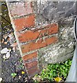
Ordnance Survey Cut Mark
This OS cut mark can be found on the wall SW side of Allotment Road. It marks a point 317.788m above mean sea level.
Image: © Adrian Dust
Taken: 4 Oct 2018
0.12 miles
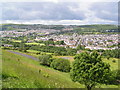
3
Bryn Awelon houses near Beaufort
Viewed from the corner of Ty'r Meddyg http://www.geograph.org.uk/photo/3977611 looking across the Beaufort to Ebbw Vale road.
Image: © Jaggery
Taken: 10 Sep 2013
0.17 miles
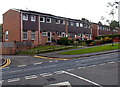
5
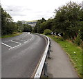
Roadside barrier on a bend in the road from Beaufort to Ebbw Vale
The road descends from Beaufort towards Ebbw Vale.
Image: © Jaggery
Taken: 10 Sep 2013
0.18 miles
6

Site of the first church in Beaufort
The board on the right records that on this site stood Bethesda Presbyterian Chapel,
the oldest church in Beaufort (opened in 1828, closed in 1986).
The location is the south side of the A4047 Beaufort Rise.
Image: © Jaggery
Taken: 10 Sep 2013
0.18 miles
7
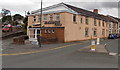
Badminton Club, Ebbw Vale
On the corner of Beaufort Terrace and Cwm Hir.
A sign pointing left towards Cwm Hir shows ¾ (mile) to Carmeltown.
Image: © Jaggery
Taken: 10 Sep 2013
0.19 miles
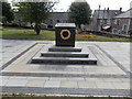
8
Rassau and Beaufort War Memorial compound
Located in Bethesda Church Memorial Garden on the south side of Beaufort Rise in Beaufort.
The inscription on the marble memorial http://www.geograph.org.uk/photo/3936346 is
All that we are.
All that we have.
We owe to them.
Image: © Jaggery
Taken: 10 Sep 2013
0.19 miles
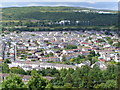
9
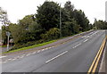
North to Beaufort
The road from Ebbw Vale to Beaufort passes broken white lines at the edge of Bryn Awelon Road. http://www.geograph.org.uk/photo/3977662
Image: © Jaggery
Taken: 10 Sep 2013
0.19 miles
10
Rassau and Beaufort War Memorial
Located here. http://www.geograph.org.uk/photo/3936292 The inscription on the marble memorial is
All that we are.
All that we have.
We owe to them.
Image: © Jaggery
Taken: 10 Sep 2013
0.19 miles