IMAGES TAKEN NEAR TO
Rassau, EBBW VALE, NP23 5DB
Introduction
This page details the photographs taken nearby to NP23 5DB by members of the Geograph project.
The Geograph project started in 2005 with the aim of publishing, organising and preserving representative images for every square kilometre of Great Britain, Ireland and the Isle of Man.

There are currently over 7.5m images from over14,400 individuals and you can help contribute to the project by visiting https://www.geograph.org.uk
Image Map
Images are licensed for reuse under creativecommons.org/licenses/by-sa/2.0
Notes
- Clicking on the map will re-center to the selected point.
- The higher the marker number, the further away the image location is from the centre of the postcode.
Image Listing (12 Images Found)
Images are licensed for reuse under creativecommons.org/licenses/by-sa/2.0
Image
Details
Distance
1
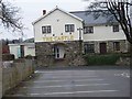
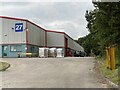
The Castle Pub, Ebbw Vale
The Castle Pub situated between Rassau housing estate and the local industrial estate, it overlooks the A465.
Image: © bracaragh
Taken: 20 Mar 2008
0.02 miles
3
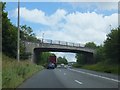
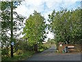
Bryn-Serth Road bridge over A465
The road provides a link between the industrial estates north of the road and the new estates in the villages to the south
Image: © David Smith
Taken: 7 Jul 2011
0.05 miles
4
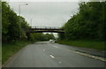
Bryn-Serth Road go over the Heads of the Valleys road
Image: © Ian S
Taken: 24 May 2014
0.05 miles
5
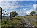
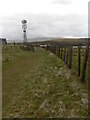
Bridleway past Wells Farm, Beaufort Wells
The white paper attached to the telegraph pole gives notice of the “Compulsory Purchase of Land and Rights Between Brynmaww and Tredegar in the County Borough of Blaenau Gwent”.
This is in connection with the dualling of the A465 road.
The bridleway which is on the route of the former Trefil tramroad will be closed at this point and a diversion created.
Image: © Robin Drayton
Taken: 27 Sep 2012
0.08 miles
6
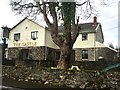
The Castle, Rassau
The Castle, a small pub / restaurant / hotel in Rassau near Ebbw Vale.
Image: © Alan Hughes
Taken: 1 Apr 2017
0.08 miles
7
Former Tramroad near to Rassau (1)
This section of the former Trefil Tramroad passes through farmland http://www.geograph.org.uk/photo/748190 just west of Beaufort Wells.
Image: © Robin Drayton
Taken: 27 Sep 2012
0.17 miles
9
Bridleway at Wells Farm
This bridleway was a former railway line parts of which are now scheduled by Cadw as important industrial monuments. In the distance is Mulfran mountain.
Image: © Colin Cheesman
Taken: 31 Mar 2008
0.22 miles
10
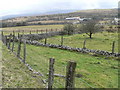
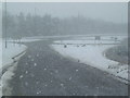
Field system - Hirgan Fields
The photograph shows network of small fields with low stone walls topped by fencing that make up Hirgan Fields between Wells Farm and Hirgan Fach. This relict of small scale agriculture will be swept away when the A465 cuts through the area. In the near distance is Bryn Serth with Mynydd Carn y Cefn dominating the far horizon.
Image: © Colin Cheesman
Taken: 31 Mar 2008
0.23 miles