IMAGES TAKEN NEAR TO
EBBW VALE, NP23 5BD
Introduction
This page details the photographs taken nearby to NP23 5BD by members of the Geograph project.
The Geograph project started in 2005 with the aim of publishing, organising and preserving representative images for every square kilometre of Great Britain, Ireland and the Isle of Man.

There are currently over 7.5m images from over14,400 individuals and you can help contribute to the project by visiting https://www.geograph.org.uk
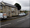
Image Map
Images are licensed for reuse under creativecommons.org/licenses/by-sa/2.0
Notes
- Clicking on the map will re-center to the selected point.
- The higher the marker number, the further away the image location is from the centre of the postcode.
Image Listing (141 Images Found)
Images are licensed for reuse under creativecommons.org/licenses/by-sa/2.0
Image
Details
Distance
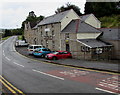
1
The King's Arms, Newtown, Ebbw Vale
Pub with accommodation viewed across Newchurch Road.
Image: © Jaggery
Taken: 10 Sep 2017
0.01 miles
2
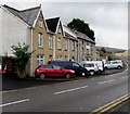
Cars, houses and a pub, Newtown, Ebbw Vale
Viewed across Newchurch Road. Houses are on the left. The King's Arms is on the right. http://www.geograph.org.uk/photo/5532033
Image: © Jaggery
Taken: 10 Sep 2017
0.01 miles
3
King's Arms, Newtown, Ebbw Vale
Large pub viewed across Newchurch Road.
Image: © Jaggery
Taken: 10 Sep 2017
0.01 miles
4
The Kings Arms, Ebbw Vale
This pub stands alongside Newchurch Road.
Image: © bracaragh
Taken: 22 Mar 2008
0.01 miles
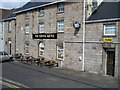
5
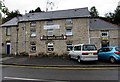
King's Arms, Newtown, Ebbw Vale
Large pub viewed across Newchurch Road. Bar entrance door on the left, lounge entrance door on the right.
In early September 2017 a banner on the wall shows Newly Refurbished En Suite Accommodation.
Image: © Jaggery
Taken: 10 Sep 2017
0.01 miles
6
Warning sign - Patrol, Newchurch Road, Newtown, Ebbw Vale
On the approach to the Pant-y-Fforest junction.
Image: © Jaggery
Taken: 10 Sep 2017
0.02 miles
7
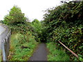
Path choice from Pont-y-gof, Ebbw Vale
Straight ahead for a path to Newchurch Road, or take the handrail-edged ascent http://www.geograph.org.uk/photo/4495255 towards Pant-y-Fforest.
Image: © Jaggery
Taken: 27 May 2015
0.02 miles
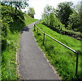
8
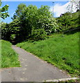
Path descending from Newchurch Road, Ebbw Vale
Towards Pont-y-Gof and Station Approach.
Image: © Jaggery
Taken: 10 Sep 2017
0.03 miles
9
Steep path up from Pontygof, Ebbw Vale
Ascending towards the corner of Newchurch Road and Pant-y-Fforest.
Image: © Jaggery
Taken: 27 May 2015
0.03 miles
10
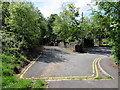
Turning area at the eastern end of Pont-y-gof, Ebbw Vale
Pont-y-gof (or Pontygof) is a street on the east side of a river bridge with the same name. http://www.geograph.org.uk/photo/4495103
Image: © Jaggery
Taken: 27 May 2015
0.04 miles