IMAGES TAKEN NEAR TO
New Church Road, EBBW VALE, NP23 5AA
Introduction
This page details the photographs taken nearby to New Church Road, NP23 5AA by members of the Geograph project.
The Geograph project started in 2005 with the aim of publishing, organising and preserving representative images for every square kilometre of Great Britain, Ireland and the Isle of Man.

There are currently over 7.5m images from over14,400 individuals and you can help contribute to the project by visiting https://www.geograph.org.uk
Image Map
Images are licensed for reuse under creativecommons.org/licenses/by-sa/2.0
Notes
- Clicking on the map will re-center to the selected point.
- The higher the marker number, the further away the image location is from the centre of the postcode.
Image Listing (57 Images Found)
Images are licensed for reuse under creativecommons.org/licenses/by-sa/2.0
Image
Details
Distance
2
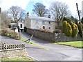
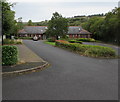
Ironmasters House, Ebbw Vale
Apparently was once an Iron Master's House, it stands alongside Newchurch Road, Ebbw Vale.
Image: © bracaragh
Taken: 22 Mar 2008
0.08 miles
3
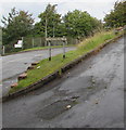
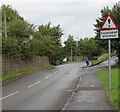
Newchurch boundary sign, Ebbw Vale
Facing Newchurch Road at the southern edge of the Newchurch area of Ebbw Vale.
Image: © Jaggery
Taken: 10 Sep 2017
0.10 miles
4
Blaenau Gwent Family Support Service in Ebbw Vale
Viewed from Beaufort Road.
Image: © Jaggery
Taken: 10 Sep 2013
0.11 miles
5
Ebbw Vale Family Resource Centre
Set back from the east side of Beaufort Road. The name sign at the entrance facing Beaufort Road shows Blaenau Gwent Family Support Service - working in partnership with Blaenau Gwent County Borough Council.
Image: © Jaggery
Taken: 10 Sep 2017
0.11 miles
6
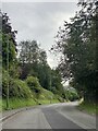
Warning sign - concealed entrance, Newchurch Road, Ebbw Vale
On the approach to the entrance to Ilsham Lea. http://www.geograph.org.uk/photo/5532178
Image: © Jaggery
Taken: 10 Sep 2017
0.12 miles
7
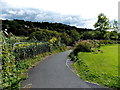
Valleys Cycle Network, Ebbw Vale
A footpath and cycleway head SE towards the valley of the Ebbw River, away from Beaufort Road.
A large sign nearby shows that this route is part of the Valleys Cycle Network and also the National Cycle Network (routes 46 and 466).
Image: © Jaggery
Taken: 10 Sep 2013
0.12 miles
8
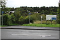
Valleys Cycle Network, Beaufort Road, Ebbw Vale
The cycle route descends from Beaufort Road on the left. The sign on the right shows Valleys Cycle Network - National Cycle Network Route 46 and 466 - Heads of the Valleys and Ebbw Vale to Cwm. The text is also in Welsh.
Image: © Jaggery
Taken: 10 Sep 2017
0.13 miles
9
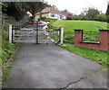
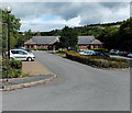
Ilsham Lea, Ebbw Vale
Above Newchurch Road.
Image: © Jaggery
Taken: 10 Sep 2017
0.13 miles
10
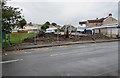
Fenced-off site behind a Beaufort Road bus stop, Ebbw Vale
Fencing encloses the site of a demolished pub, The Beaufort Arms.
Image: © Jaggery
Taken: 10 Sep 2017
0.13 miles