IMAGES TAKEN NEAR TO
King Street, EBBW VALE, NP23 4XR
Introduction
This page details the photographs taken nearby to King Street, NP23 4XR by members of the Geograph project.
The Geograph project started in 2005 with the aim of publishing, organising and preserving representative images for every square kilometre of Great Britain, Ireland and the Isle of Man.

There are currently over 7.5m images from over14,400 individuals and you can help contribute to the project by visiting https://www.geograph.org.uk
Image Map
Images are licensed for reuse under creativecommons.org/licenses/by-sa/2.0
Notes
- Clicking on the map will re-center to the selected point.
- The higher the marker number, the further away the image location is from the centre of the postcode.
Image Listing (261 Images Found)
Images are licensed for reuse under creativecommons.org/licenses/by-sa/2.0
Image
Details
Distance
1
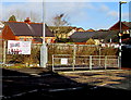
Fenced-off site of a demolished school, Brynmawr
On the north side of the A4047 King Street viewed in February 2016.
Ysgol Cymraeg http://www.geograph.org.uk/photo/1819840 was here in April 2010.
Image: © Jaggery
Taken: 2 Feb 2016
0.01 miles
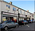
2
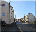
King Street Brynmawr
Looking west along the A4047 King Street.
Brynmawr Social Club http://www.geograph.org.uk/photo/4815010 is on the left. A Lloyds Bank branch http://www.geograph.org.uk/photo/4814966 is ahead on the right.
Image: © Jaggery
Taken: 2 Feb 2016
0.01 miles
3
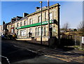
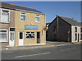
Lloyds Bank, Brynmawr
Bank branch (sort code 30-92-97) at 72 King Street, Brynmawr.
The fencing on the right is at the edge of a demolished school site. http://www.geograph.org.uk/photo/4814972
Image: © Jaggery
Taken: 2 Feb 2016
0.01 miles
4
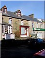
Brynmawr Law office, Brynmawr
The Magistrates' Court and County Court advocacy office is at 74 King Street,
next door to the Lloyds Bank Brynmawr branch. http://www.geograph.org.uk/photo/4814966
Image: © Jaggery
Taken: 2 Feb 2016
0.01 miles
5
Northwest end of Beaufort Street, Brynmawr
Looking along Beaufort Street towards King Street in early February 2016.
Nearest the camera is Hosbis y Cymoedd (Hospice of the Valleys) charity shop. Also in view are a Mencap Cymru office, Bev's Beauty salon and Legends pub (formerly the Kings Head) at 1 Beaufort Street.
Image: © Jaggery
Taken: 2 Feb 2016
0.02 miles
6
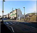
Zebra crossing, King Street, Brynmawr
In February 2016, the zebra crossing across the A4047 King Street is to the edge of a fenced-off site,
the location of the demolished Ysgol Gymraeg seen here http://www.geograph.org.uk/photo/1819840 in April 2010.
On each side of the crossing are combined Belisha beacons and street lamps.
A Lloyds Bank branch http://www.geograph.org.uk/photo/4814966 is on the right.
Image: © Jaggery
Taken: 2 Feb 2016
0.02 miles
7
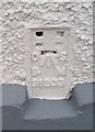
Ordnance Survey Flush Bracket (S1203)
This OS Flush Bracket can be found on No71 King Street. It marks a point 363.416m above mean sea level.
Image: © Adrian Dust
Taken: 4 Oct 2018
0.02 miles
8
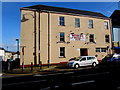
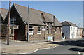
Brynmawr Social Club, Brynmawr
Club at 61 Beaufort Street on the corner of King Street, viewed in February 2016.
The name on this wall in an October 2009 Google Earth Street View was
Brynmawr Royal British Legion Club & Institute Ltd.
Image: © Jaggery
Taken: 2 Feb 2016
0.02 miles
9
Ysgol Gymraeg, Brynmawr
Ysgol Gymraeg (Welsh School) Junior and infants school, King Street.
Pupils are aged 4 to 11 (reception through to Year 6).
Image: © Jaggery
Taken: 21 Apr 2010
0.02 miles
10
Corner of King Street and Queen Street, Brynmawr
Lake's Collectables shop is on the corner of King Street (in the foreground) and Queen Street.http://www.geograph.org.uk/photo/1819844
Image: © Jaggery
Taken: 21 Apr 2010
0.02 miles