1
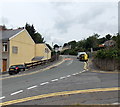
The Walk, Blaina
The Walk climbs away from the corner of Park View. There is a 20mph speed limit ahead on the approach to Coed y Garn Primary School, Nantyglo.
Image: © Jaggery
Taken: 26 Jul 2013
0.07 miles
2
Road and bus stop
Image: © Nick Mutton 01329 000000
Taken: 15 Dec 2007
0.09 miles
3
New house being built on the corner of The Walk and Park View, Blaina
Viewed across Surgery Road in late July 2013.
Image: © Jaggery
Taken: 26 Jul 2013
0.11 miles
4
Parrot Row Nantyglo
Parrot Row heads away from Queen Street. Coed y Garn Primary School is on the right.
Image: © Jaggery
Taken: 26 Jul 2013
0.12 miles
5
Wildlife area, Blaina Scouts HQ
The grassland is part of the wildlife area in the grounds of the Scout HQ, Atlee Road.
Image: © M J Roscoe
Taken: 18 Oct 2016
0.14 miles
6
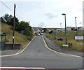
Surgery Road, Nantyglo and Blaina
Surgery Road heads into Blaina away from High Street in Nantyglo.
Image: © Jaggery
Taken: 26 Jul 2013
0.14 miles
7
Ordnance Survey Cut Mark
This OS cut mark can be found on No11 Surgery Road. It marks a point 327.748m above mean sea level.
Image: © Adrian Dust
Taken: 30 Jun 2023
0.15 miles
8
Fork in the path, Central Park, Blaina
At the northern edge of the park, near the entrance http://www.geograph.org.uk/photo/3572871 from Surgery Road.
Image: © Jaggery
Taken: 26 Jul 2013
0.15 miles
9
Row of houses, High Street, Nantyglo
The houses are between Parrot Row http://www.geograph.org.uk/photo/3571882 behind the camera and Surgery Road ahead.
This is the southern edge of Nantyglo. The northern boundary of Blaina is near Surgery Road.
Image: © Jaggery
Taken: 26 Jul 2013
0.16 miles
10
Northern entrance to Central Park, Blaina
This entrance is from Surgery Road at the northern edge of the park. There is a large sports field in the south of the park.
Image: © Jaggery
Taken: 26 Jul 2013
0.16 miles


