IMAGES TAKEN NEAR TO
The Crescent, EBBW VALE, NP23 4UN
Introduction
This page details the photographs taken nearby to The Crescent, NP23 4UN by members of the Geograph project.
The Geograph project started in 2005 with the aim of publishing, organising and preserving representative images for every square kilometre of Great Britain, Ireland and the Isle of Man.

There are currently over 7.5m images from over14,400 individuals and you can help contribute to the project by visiting https://www.geograph.org.uk
Image Map
Images are licensed for reuse under creativecommons.org/licenses/by-sa/2.0
Notes
- Clicking on the map will re-center to the selected point.
- The higher the marker number, the further away the image location is from the centre of the postcode.
Image Listing (30 Images Found)
Images are licensed for reuse under creativecommons.org/licenses/by-sa/2.0
Image
Details
Distance
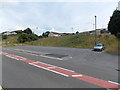
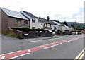
1
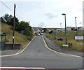
Parrot Row Nantyglo
Parrot Row heads away from Queen Street. Coed y Garn Primary School is on the right.
Image: © Jaggery
Taken: 26 Jul 2013
0.11 miles
2
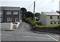
Road to Lower Coedcae, Nantyglo
Viewed across Queen Street. A sign on the right corner points towards Lower Coedcae.
Image: © Jaggery
Taken: 26 Jul 2013
0.14 miles
3
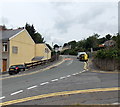
The Walk, Blaina
The Walk climbs away from the corner of Park View. There is a 20mph speed limit ahead on the approach to Coed y Garn Primary School, Nantyglo.
Image: © Jaggery
Taken: 26 Jul 2013
0.14 miles
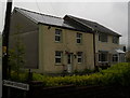
4
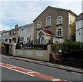
Former Bethel chapel, Nantyglo
Viewed across Queen Street. Now converted to a private residence, the building on the right was erected in 1867 as Bethel English Baptist chapel. The "English" in the name denoted the language used for services in an area that was mainly Welsh speaking at the time.
Image: © Jaggery
Taken: 26 Jul 2013
0.15 miles
5
Parking area at the edge of Coed y Garn Primary School, Nantyglo
The parking area is alongside Queen Street at the corner of Parrot Row. http://www.geograph.org.uk/photo/3571882
Image: © Jaggery
Taken: 26 Jul 2013
0.15 miles

8
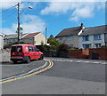
Royal Mail van in Nantyglo
Parked at the edge of Queen Street.
Is the red and white chequered pattern a Royal Mail version of go faster stripes?
Image: © Jaggery
Taken: 18 Sep 2013
0.17 miles
9
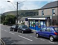
B&S Stores, Nantyglo
Shop and off licence in Queen Street.
Image: © Jaggery
Taken: 26 Jul 2013
0.18 miles
10
Row of houses, High Street, Nantyglo
The houses are between Parrot Row http://www.geograph.org.uk/photo/3571882 behind the camera and Surgery Road ahead.
This is the southern edge of Nantyglo. The northern boundary of Blaina is near Surgery Road.
Image: © Jaggery
Taken: 26 Jul 2013
0.19 miles