IMAGES TAKEN NEAR TO
Roundhouse Close, EBBW VALE, NP23 4QY
Introduction
This page details the photographs taken nearby to Roundhouse Close, NP23 4QY by members of the Geograph project.
The Geograph project started in 2005 with the aim of publishing, organising and preserving representative images for every square kilometre of Great Britain, Ireland and the Isle of Man.

There are currently over 7.5m images from over14,400 individuals and you can help contribute to the project by visiting https://www.geograph.org.uk
Image Map
Images are licensed for reuse under creativecommons.org/licenses/by-sa/2.0
Notes
- Clicking on the map will re-center to the selected point.
- The higher the marker number, the further away the image location is from the centre of the postcode.
Image Listing (46 Images Found)
Images are licensed for reuse under creativecommons.org/licenses/by-sa/2.0
Image
Details
Distance
1
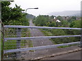
The A467 at Nantyglo from the Wesley Bridge
Image: © Carol Rose
Taken: 16 Jun 2007
0.05 miles
2
Market Road, Nantyglo
The northern end of Market Road, viewed from opposite Nantyglo Wesley Methodist Church. http://www.geograph.org.uk/photo/2281304
The street name sign includes LEADING TO FARM ROAD.
Image: © Jaggery
Taken: 3 Feb 2011
0.05 miles
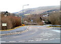
3
Corner of Roundhouse Close, Nantyglo
Viewed from an unnamed section of main road. http://www.geograph.org.uk/photo/2281137
Image: © Jaggery
Taken: 3 Feb 2011
0.07 miles
4
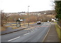
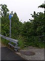
Bus stops adjacent to Roundhouse Close, Nantyglo
The bus stops are on an unnamed section of road between Waun Ebbw Road and the T-junction (out of shot ahead) with Chapel Road/New Road. The turning into Roundhouse Close is on the right, near the triangular white side of a building.
Image: © Jaggery
Taken: 3 Feb 2011
0.07 miles
5
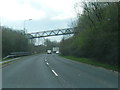
A467 passing under footbridge at Nantyglo
Image: © Colin Pyle
Taken: 21 Apr 2018
0.08 miles
7
Footpath to the side of the A467 from the Wesley bridge
Image: © Carol Rose
Taken: 16 Jun 2007
0.10 miles
8
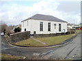
Nantyglo Wesley Methodist Church
Located on Chapel Road. A tablet on the side of the building shows
ENGLISH WESLEYAN CHAPEL 1825.
English was the language of the church services in 1825 when Welsh was the everyday language for most people in the area.
Image: © Jaggery
Taken: 3 Feb 2011
0.11 miles
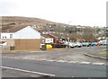
9
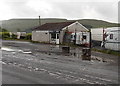
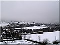
New Road Garage, Nantyglo
Puddles lie in the road after a brief, heavy shower. At an elevation of about 1,100 ft (c 340m) above sea level, this part of Blaenau Gwent has copious rainfall, averaging about 1,500 mm annually, which is nearly 300% of the total recorded in the drier parts of England.
Image: © Jaggery
Taken: 14 Jun 2013
0.11 miles
10
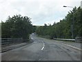
Bridge over A467 in Nantyglo
The bridge is known as the Wesley Bridge. There are traffic calming measures on the road (to deter speeding?)
Image: © David Smith
Taken: 7 Jul 2011
0.12 miles