IMAGES TAKEN NEAR TO
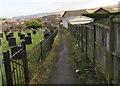
Churchfields, EBBW VALE, NP23 4QA
Introduction
This page details the photographs taken nearby to Churchfields, NP23 4QA by members of the Geograph project.
The Geograph project started in 2005 with the aim of publishing, organising and preserving representative images for every square kilometre of Great Britain, Ireland and the Isle of Man.

There are currently over 7.5m images from over14,400 individuals and you can help contribute to the project by visiting https://www.geograph.org.uk
Image Map
Images are licensed for reuse under creativecommons.org/licenses/by-sa/2.0
Notes
- Clicking on the map will re-center to the selected point.
- The higher the marker number, the further away the image location is from the centre of the postcode.
Image Listing (196 Images Found)
Images are licensed for reuse under creativecommons.org/licenses/by-sa/2.0
Image
Details
Distance
1
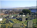
Path descending past the southern edge of a churchyard, Brynmawr
Descending from Clydach Street towards the north side of the Church of St Mary the Virgin. http://www.geograph.org.uk/photo/4830400
Image: © Jaggery
Taken: 2 Feb 2016
0.01 miles
2
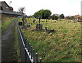
West along a churchyard path in Brynmawr
Looking towards Clydach Street. The churchyard is on the north side of the Church of St Mary the Virgin. http://www.geograph.org.uk/photo/4830400
Image: © Jaggery
Taken: 2 Feb 2016
0.01 miles
3
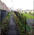
Path towards Clydach Street, Brynmawr
Past the southern edge of this http://www.geograph.org.uk/photo/4830649 burial ground.
Image: © Jaggery
Taken: 2 Feb 2016
0.02 miles
4
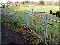
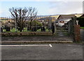
Churchyard entrance gate, Brynmawr
From this path. http://www.geograph.org.uk/photo/4830613
Image: © Jaggery
Taken: 2 Feb 2016
0.02 miles
6
Gate to a path past the edge of a churchyard, Brynmawr
The gate gives access from Clydach Street to this http://www.geograph.org.uk/photo/4830668 path.
Image: © Jaggery
Taken: 2 Feb 2016
0.03 miles
7

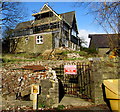
Grade II listed vicarage, Brynmawr
Located about 25 metres southwest of the Church of St Mary the Virgin, http://www.geograph.org.uk/photo/4830378
the vicarage was built in 1886-1888, Grade II listed in 1999.
Image: © Jaggery
Taken: 2 Feb 2016
0.03 miles
8
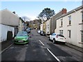
Dumfries Place, Brynmawr
Viewed from near the corner of King Street looking towards a Grade II listed vicarage. http://www.geograph.org.uk/photo/4830509
Image: © Jaggery
Taken: 2 Feb 2016
0.03 miles
9
Vicarage and church, Brynmawr
The Grade II listed late Victorian vicarage http://www.geograph.org.uk/photo/4830488 is on the left.
The Church in Wales Church of St Mary the Virgin, Brynmawr http://www.geograph.org.uk/photo/4830378 is on the right.
Image: © Jaggery
Taken: 2 Feb 2016
0.03 miles
10
Heddfan, Brynmawr
Heddfan is a cul-de-sac extending for nearly 100 metres from the east side of Queen Street.
Image: © Jaggery
Taken: 2 Feb 2016
0.04 miles