IMAGES TAKEN NEAR TO
Brynhyfryd Avenue, EBBW VALE, NP23 4PB
Introduction
This page details the photographs taken nearby to Brynhyfryd Avenue, NP23 4PB by members of the Geograph project.
The Geograph project started in 2005 with the aim of publishing, organising and preserving representative images for every square kilometre of Great Britain, Ireland and the Isle of Man.

There are currently over 7.5m images from over14,400 individuals and you can help contribute to the project by visiting https://www.geograph.org.uk
Image Map
Images are licensed for reuse under creativecommons.org/licenses/by-sa/2.0
Notes
- Clicking on the map will re-center to the selected point.
- The higher the marker number, the further away the image location is from the centre of the postcode.
Image Listing (22 Images Found)
Images are licensed for reuse under creativecommons.org/licenses/by-sa/2.0
Image
Details
Distance
1
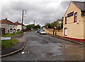
Gwent Terrace north of Ffosmaen Road, Nantyglo
Viewed from the corner of Ffosmaen Road looking north along Gwent Terrace towards Milfraen Avenue.
The former Ffosmaen Inn http://www.geograph.org.uk/photo/3516391 is on the right.
Image: © Jaggery
Taken: 14 Jun 2013
0.12 miles
2
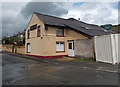
Former Ffosmaen Inn, Nantyglo
Now a private residence, the building on the corner of Ffosmaen Road
and Gwent Terrace used to be the Ffosmaen Inn.
Image: © Jaggery
Taken: 14 Jun 2013
0.15 miles
3
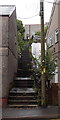
Steps from King Street to Prince Street, Nantyglo
The short cut bends to the left at the top of these steps.
Image: © Jaggery
Taken: 14 Jun 2013
0.15 miles
4
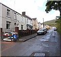
Ffosmaen Road houses, Nantyglo
The houses are all on one side of the road, facing a cemetery.
Image: © Jaggery
Taken: 14 Jun 2013
0.16 miles
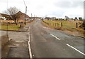
5
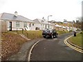
Banna Park Bungalows, Nantyglo
A cul-de-sac connecting to Porters Road via Golf View. http://www.geograph.org.uk/photo/2281414 The bungalows face a recreation ground.
Image: © Jaggery
Taken: 3 Feb 2011
0.17 miles
6
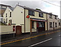
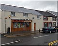
Nantyglo Village Store and Post Office
Located at 69 King Street, Nantyglo.
Image: © Jaggery
Taken: 14 Jun 2013
0.18 miles
7
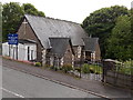
Holy Trinity & St Anne church, Nantyglo
The Church in Wales church is set a little below road level at the northern end of King Street.
Image: © Jaggery
Taken: 14 Jun 2013
0.18 miles
8
Conversion of former Nantyglo Institute to housing
A notice outside the former Nantyglo Institute in New Road states that luxury maisonettes will be available to rent here from March. Presumably March 2014 is meant. Conversion work was at an early stage at the mid-June 2013 date of this view.
Image: © Jaggery
Taken: 14 Jun 2013
0.19 miles
9
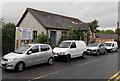
Nantyglo Stores, Nantyglo
Convenience stores in King Street.
Image: © Jaggery
Taken: 14 Jun 2013
0.19 miles
10
Porters Road, Nantyglo
Heading southeastwards, Porters Road climbs away from the edge of the Nantyglo RFC clubhouse site. http://www.geograph.org.uk/photo/2281439
Image: © Jaggery
Taken: 3 Feb 2011
0.19 miles