1
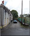
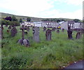
Co-operative Terrace, Nantyglo
Short terrace of 3 houses, viewed from Ffosmaen Road.
Image: © Jaggery
Taken: 14 Jun 2013
0.00 miles
2
Garn IT, Nantyglo
Technology services business at 39 Garn Cross, at the junction with Garn Road on the right.
Image: © Jaggery
Taken: 14 Jun 2013
0.02 miles
3
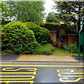
Site of the demolished Hermon Baptist Church, Nantyglo
Viewed across the street named Garn Cross. A black plaque on the wall behind the bus stop records that this was the site of Hermon Baptist Church from 1820 until 1987. The site is now occupied by Nantyglo Medical Centre. http://www.geograph.org.uk/photo/3570771
Image: © Jaggery
Taken: 14 Jun 2013
0.04 miles
4
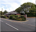
Nantyglo Medical Centre
Viewed across Queen Street. This site was occupied by Hermon Baptist Church from 1820-1987.
Image: © Jaggery
Taken: 26 Jul 2013
0.04 miles
5
Garn Cross Car Park, Nantyglo
Small free car park on the south side of the street named Garn Cross.
Image: © Jaggery
Taken: 14 Jun 2013
0.04 miles
6
Tasty Garden, Nantyglo
Chinese and Cantonese cuisine takeaway located at the SE end of King Street, at number 96.
Image: © Jaggery
Taken: 14 Jun 2013
0.05 miles
7
Cemetery of a demolished church, Nantyglo
Viewed from the Ffosmaen Road side. The cemetery, about 180 metres by 50 metres, was formerly the churchyard on the NE side of Hermon Baptist Church (1820-1987).
Image: © Jaggery
Taken: 14 Jun 2013
0.08 miles
8
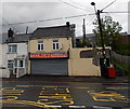
Sold sign on former Ken Finney Motorcycles shop, Nantyglo
Viewed across Queen Street in late July 2013.
Image: © Jaggery
Taken: 26 Jul 2013
0.09 miles
9
Nantyglo Stores, Nantyglo
Convenience stores in King Street.
Image: © Jaggery
Taken: 14 Jun 2013
0.11 miles
10
Former Ffosmaen Inn, Nantyglo
Now a private residence, the building on the corner of Ffosmaen Road
and Gwent Terrace used to be the Ffosmaen Inn.
Image: © Jaggery
Taken: 14 Jun 2013
0.12 miles


