IMAGES TAKEN NEAR TO
Warwick Road, EBBW VALE, NP23 4HW
Introduction
This page details the photographs taken nearby to Warwick Road, NP23 4HW by members of the Geograph project.
The Geograph project started in 2005 with the aim of publishing, organising and preserving representative images for every square kilometre of Great Britain, Ireland and the Isle of Man.

There are currently over 7.5m images from over14,400 individuals and you can help contribute to the project by visiting https://www.geograph.org.uk
Image Map
Images are licensed for reuse under creativecommons.org/licenses/by-sa/2.0
Notes
- Clicking on the map will re-center to the selected point.
- The higher the marker number, the further away the image location is from the centre of the postcode.
Image Listing (42 Images Found)
Images are licensed for reuse under creativecommons.org/licenses/by-sa/2.0
Image
Details
Distance
1
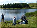
North shore, Machine Pond, Parc Nant-y-Waun
The eastern part of the north shore of Machine Pond, originally an industrial reservoir.
Image: © M J Roscoe
Taken: 7 Feb 2017
0.08 miles
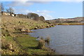
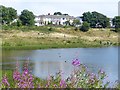
2
Machine Pond, Brynmawr
The eastern end of the pond as viewed from Warwick Road.
Image: © Robin Drayton
Taken: 16 Aug 2013
0.08 miles
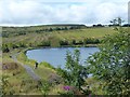
3
Mustard Pond, Parc Nant-y-Waun
Pond on reclaimed land at the eastern end of Parc Nant-y-Waun.
Image: © M J Roscoe
Taken: 7 Feb 2017
0.09 miles
4

Small white butterfly on Rosebay Willowherb, Parc Nant-y-Waun, Brynmawr
With an abundance of Rosebay Willowherb http://www.geograph.org.uk/photo/3611008 , there were numerous second brood butterflies settling on these plants.
Image: © Robin Drayton
Taken: 16 Aug 2013
0.09 miles
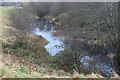
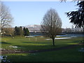
5
View across Machine Pond, Brynmawr
Looking towards Warwick Road.
Image: © Robin Drayton
Taken: 16 Aug 2013
0.12 miles

8
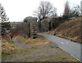
Footpath and remains of a railway viaduct, Brynmawr
The fragment of a railway viaduct is located on the south side of Warwick Road, about 250 metres west of the site of the demolished Brynmawr railway station.
Image: © Jaggery
Taken: 3 Feb 2011
0.15 miles
9
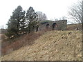
Remains of a railway viaduct, Brynmawr
This fragment of a railway viaduct is on the south side of Warwick Road. Brynmawr railway station, now demolished, was about 250 metres to the east.
Image: © Jaggery
Taken: 3 Feb 2011
0.15 miles