IMAGES TAKEN NEAR TO
Blaenavon Road, EBBW VALE, NP23 4BU
Introduction
This page details the photographs taken nearby to Blaenavon Road, NP23 4BU by members of the Geograph project.
The Geograph project started in 2005 with the aim of publishing, organising and preserving representative images for every square kilometre of Great Britain, Ireland and the Isle of Man.

There are currently over 7.5m images from over14,400 individuals and you can help contribute to the project by visiting https://www.geograph.org.uk
Image Map
Images are licensed for reuse under creativecommons.org/licenses/by-sa/2.0
Notes
- Clicking on the map will re-center to the selected point.
- The higher the marker number, the further away the image location is from the centre of the postcode.
Image Listing (16 Images Found)
Images are licensed for reuse under creativecommons.org/licenses/by-sa/2.0
Image
Details
Distance
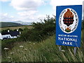
2
Brecon Beacons National Park boundary sign east of Brynmawr
Alongside the B4248, the road from Brynmawr to Blaenavon.
Image: © Jaggery
Taken: 14 Sep 2013
0.05 miles
3
Descent towards Brynmawr
Viewed from the edge of a parking area http://www.geograph.org.uk/photo/3655558 alongside the B4248. Houses in Brynmawr are in the distance.
Image: © Jaggery
Taken: 14 Sep 2013
0.05 miles
4
Parking area on the south side of the B4248 east of Brynmawr
The 40-metre long parking area is about 430 metres (c1,410 ft) above sea level.
Image: © Jaggery
Taken: 14 Sep 2013
0.09 miles
5
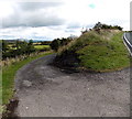
Access lane to Rhas Fawr Farm east of Brynmawr
Viewed from the edge of the B4248 on the right. The farm is about 150 metres ahead along the lane.
Image: © Jaggery
Taken: 14 Sep 2013
0.09 miles
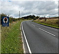
6
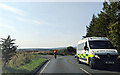
Cyclist and Ambulance on the B4248 Blaen-afon Road, looking west
Image: © Rob Purvis
Taken: 14 Sep 2022
0.10 miles
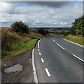
7
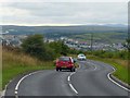
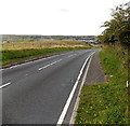
Approaching Brynmawr
This is the B4248 from Blaenavon as it starts its descent to Brynmawr.
The distinctive outline of the Brecon Beacons http://www.geograph.org.uk/photo/2631725 can be seen at the top right.
Image: © Robin Drayton
Taken: 28 Aug 2013
0.13 miles
9
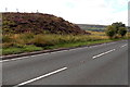
Edge of a small moorland ridge east of Brynmawr
Viewed across the B4248 on the descent into Brynmawr.
Image: © Jaggery
Taken: 14 Sep 2013
0.15 miles
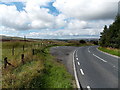
10
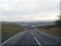
Start of the pavement on the eastern approach to Brynmawr
At last! After many kilometres of at best thin grass verges alongside a busy moorland road from Blaenavon (the B4248) the wary (and perhaps weary) walker can relax a little now!
Image: © Jaggery
Taken: 14 Sep 2013
0.16 miles