IMAGES TAKEN NEAR TO
Waenheulog, EBBW VALE, NP23 4BE
Introduction
This page details the photographs taken nearby to Waenheulog, NP23 4BE by members of the Geograph project.
The Geograph project started in 2005 with the aim of publishing, organising and preserving representative images for every square kilometre of Great Britain, Ireland and the Isle of Man.

There are currently over 7.5m images from over14,400 individuals and you can help contribute to the project by visiting https://www.geograph.org.uk
Image Map
Images are licensed for reuse under creativecommons.org/licenses/by-sa/2.0
Notes
- Clicking on the map will re-center to the selected point.
- The higher the marker number, the further away the image location is from the centre of the postcode.
Image Listing (27 Images Found)
Images are licensed for reuse under creativecommons.org/licenses/by-sa/2.0
Image
Details
Distance
1
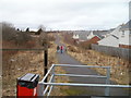
Path between Lakeside Way and Waunheulog, Nantyglo
A path heads NW away from Pond Road. The houses on the right are on Lakeside Way.
Image: © Jaggery
Taken: 3 Feb 2011
0.04 miles
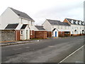
2
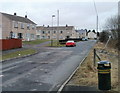
Waunheulog, Nantyglo
Houses on the SE side of Waunheulog, an area of about 150 houses. Waunhelog connects with the junction of Golf Road and Pond Road.
Image: © Jaggery
Taken: 3 Feb 2011
0.04 miles
3
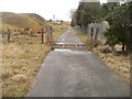
Cattle grid across a lane near to Golf Road, Nantyglo
An unnamed lane heads NW from Golf Road http://www.geograph.org.uk/photo/2280963 through moorland at about 350 metres (1150 feet) above sea level.
Image: © Jaggery
Taken: 3 Feb 2011
0.05 miles
4
The start of the bridleway with old spoil heaps beyond
Image: © Carol Rose
Taken: 16 Jun 2007
0.06 miles
5
Southern side of Lakeside Way, Nantyglo
Viewed from the corner of Pond Road. The houses face Waun Pond. http://www.geograph.org.uk/photo/2259892
Image: © Jaggery
Taken: 3 Feb 2011
0.10 miles
6
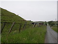
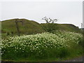
Sheep graze on the side of an old spoil heap
Image: © Carol Rose
Taken: 16 Jun 2007
0.10 miles
7
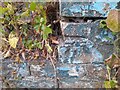
Ordnance Survey Cut Mark
This OS cut mark can be found on the damaged gatepost SW side of the road. It marks a point 348.188m above mean sea level.
Image: © Adrian Dust
Taken: 30 Jun 2023
0.10 miles
8
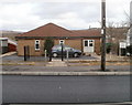
Winchestown Senior Citizens Hall, Nantyglo
Viewed across Waun Ebbw Road.
Image: © Jaggery
Taken: 3 Feb 2011
0.10 miles
9
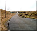
Golf Road, Nantyglo
Taken at about 355 metres (1165 feet) above sea level, this early February view of Golf Road, near the Pond Road end, shows a bleak moorland scene. Ahead, the road climbs towards West Monmouthshire Golf Club. http://www.geograph.org.uk/photo/469395 The 14th tee is at 1500 feet (about 455 metres) above sea level, making West Mon the highest golf course in Great Britain.
Image: © Jaggery
Taken: 3 Feb 2011
0.10 miles
10
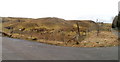
Former mining tips, Nantyglo
Grass has grown on mounds composed of mining waste, alongside Golf Road. http://www.geograph.org.uk/photo/2280963
Image: © Jaggery
Taken: 3 Feb 2011
0.10 miles